Good Morning. This is Alex Marienthal with the Gallatin National Forest Avalanche Forecast on Sunday, March 1st at 7:00 a.m. Today’s forecast is sponsored by Yellowstone Arctic Yamaha and Beartooth Powder Guides. This forecast does not apply to operating ski areas.
Last night the mountains around Hyalite got 5” of snow and 1-3” fell elsewhere. This morning wind is north-northwest at 5-15 mph and temperatures are single digits to high teens F. Today will be partly cloudy with temperatures briefly reaching low 20s F, northerly wind at 5-15 mph and scattered light snow showers. An inch or two of snow is possible before skies clear overnight.

Recent human triggered and natural avalanches are evidence that potentially deadly avalanches can break deep in the snowpack. On Thursday, a trail groomer in the northern Gallatin Range triggered a slide that broke 2-3’ deep, 100’ wide and 600’ long on a west facing slope at 7,800’ elevation (video, photo and details). The avalanche rolled and partially buried the vehicle, and the driver was unharmed. On Wednesday, natural avalanches broke 3-5’ deep in the Hourglass chute north of Bridger Bowl (photos and details) and near Divide Peak in Hyalite (photos and details). Avoid steep slopes where the snowpack has potential shallow trigger points. These include lower elevation slopes with a relatively shallower snowpack similar to where the groomer triggered slide occurred, and higher elevations where snow depth varies greatly like rocky, heavily wind loaded slopes or slopes with large cornices above.
Cornices are overhanging waves of snow along ridgelines and literally weigh a ton. They can be triggered by a skier or snowmobiler, break back farther from the edge than expected and make a good trigger for deep slab avalanches. The recent slide in The Hourglass was triggered by a large cornice (photo). Stay far back from the edge of ridgelines and avoid slopes below large cornices.
Last night’s 2-5” of snow equaled 0.1-0.5” of snow water equivalent (SWE) and with minimal wind does not greatly increase hazard today. Watch for cracking in the snow surface or blowing snow as a sign of unstable fresh drifts. Dry loose avalanches are possible where new snow is deeper. Today, weak snow near the bottom of the snowpack creates heightened avalanche conditions and avalanche danger is MODERATE.

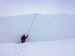
Near West Yellowstone and Cooke City the snowpack is generally stable and avalanches are unlikely. Last night’s 1-3” of snow equaled 0.1-0.2” of SWE and adds minimal hazard. On Thursday skiers in Specimen Creek in the southern Gallatin Range got a collapse on weak snow near the ground (details). Yesterday, skiers in the same area dialed back their terrain choices after getting an Extended Column Test to propagate on 29 hits (ECTP 29). Weak snow near the ground has not produced an avalanche in these mountains for several weeks, but requires us to remain diligent with thoughtful decision making, careful snowpack assessment and safe travel protocols (video, video). Today avalanches are unlikely and avalanche danger is LOW.
If you get out, please send us your observations no matter how brief. You can fill out an observation form, email us (mtavalanche@gmail.com), leave a VM at 406-587-6984, or Instagram (#gnfacobs).
Upcoming Avalanche Education and Events
Our education calendar is full of awareness lectures and field courses. Check it out and plan to attend one or two: Events and Education Calendar.
COOKE CITY
Every Friday and Saturday, Snowpack Update and Rescue Training. Friday, 6:30-7:30 p.m. at the Soda Butte Lodge. Saturday anytime between 10-2 @ Round Lake.
BOZEMAN
February 27 - March 1, Bozeman Splitfest, More info and schedule here.
March 4, 1-hr Avalanche Awareness. 6-7 p.m. at REI.
March 6 and 7, She Jumps Companion Rescue Clinic, Fri 6-8 p.m. and Sat 10a-2p. More info and Register HERE.
BILLINGS
March 12, 1-hr Avalanche Awareness, 6-7 p.m. at The Basecamp.
Earlier this season, MSU film student, Nate Kenney made this video to profile the GNFAC forecaster(s) and what we do. Thanks, Nate! Nice job.