Good Morning. This is Ian Hoyer with the Gallatin National Forest Avalanche Forecast on Saturday, February 29th at 7:00 a.m. Today’s forecast is sponsored by Yellowstone Club Community Foundation and Knoff Group Real Estate. This forecast does not apply to operating ski areas.
This morning there is no new snow. Mountain temperatures are in the 20s to low 30s F and winds are 20-30 mph out of south and southwest with gusts of 40-50 mph. Today will be mostly cloudy with light precipitation starting this afternoon. There may be a drizzle of rain at lower elevations before it switches over to snow. High temperatures will be in the high 20s and 30s F with moderate southwest winds gusting up to 30-40 mph. A trace to 2” of snow will accumulate by tomorrow morning.

While today is Leap Day it feels more like Groundhog Day. It’s like we’re stuck in a loop. Every day this season we’ve warned you about the weak snow at the ground. Today is no different. That weak snow is still there and it is still a problem.
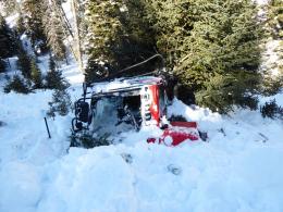
On Thursday night, a snowmobile trail groomer was up Swan Creek in the northern Gallatin Range and triggered an avalanche that broke 2-3’ deep, 100’ wide, and ran 600’ on a west facing slope at 7800’ (video, photo and details). It pushed the groomer 100’ off the road, rolling it and partially burying it. The vehicle protected him and the operator was unharmed. A skier or snowmobiler wouldn’t have been as lucky. This avalanche broke on the weak, sugary, faceted snow at the ground. It is easier to affect the weak layer and trigger an avalanche on thinner slopes, but avalanches on slopes with a deeper snowpack will be larger. Neither is a good recipe. After a couple days without loading, slopes aren’t on a hair trigger. However, this slide and natural avalanches that broke mid-week near Divide Peak in Hyalite (photos and details) and in the Hourglass Chute in the Bridger’s (photos and details) demonstrate that dangerous slides are still possible if you find just the wrong spot.
“Never trust a depth hoar snowpack” is an adage among avalanche professionals. This season is demonstrating the truth of that phrase. Stay conservative to stay safe.
Human triggered avalanches are possible and the avalanche danger is rated MODERATE.

Triggering a large avalanche is unlikely near Cooke City and West Yellowstone. A number of small avalanches broke in thin wind drifts near Cooke City earlier this week, but with warm temperatures they will mostly be glued on at this point (photo, photo). A big collapse on Thursday at Specimen Creek is a reminder that while very unlikely (we’re several weeks out from the last large avalanche), avalanches breaking at the ground still deserve a spot in the back of your mind (details, video, video). The avalanche danger is LOW today.
If you get out, please send us your observations no matter how brief. You can fill out an observation form, email us (mtavalanche@gmail.com), leave a VM at 406-587-6984, or Instagram (#gnfacobs).
Upcoming Avalanche Education and Events
Our education calendar is full of awareness lectures and field courses. Check it out and plan to attend one or two: Events and Education Calendar.
COOKE CITY
Every Friday and Saturday, Snowpack Update and Rescue Training. Friday, 6:30-7:30 p.m. at the Soda Butte Lodge. Saturday anytime between 10-2 @ Round Lake.
BOZEMAN
February 27 - March 1, Bozeman Splitfest, More info and schedule here.
March 4, 1-hr Avalanche Awareness. 6-7 p.m. at REI.
March 6 and 7, She Jumps Companion Rescue Clinic, Fri 6-8 p.m. and Sat 10a-2p. More info and Register HERE.
BILLINGS
March 12, 1-hr Avalanche Awareness, 6-7 p.m. at The Basecamp.
Headed to the Sweet Grass County Recreation Association’s Poker Run today up the Main Boulder south of Big Timber? We went out on Thursday to check on conditions before the ride, watch our video update HERE.