Good Morning. This is Doug Chabot with the Gallatin National Forest Avalanche Advisory issued on Wednesday, February 28th at 7:00 a.m. Today’s advisory is sponsored by Yellowstone Arctic Yamaha and Yamaha Motor Corp in partnership with the Friends of the Avalanche Center. This advisory does not apply to operating ski areas.
At 5 a.m. under partly cloudy skies, temperatures are in the single digits and winds are W-SW averaging 10-15 mph with gusts of 30 mph. Today will be partly cloudy, temperatures will rise into the high teens and winds will remain the same. There is no snow expected until Thursday evening.
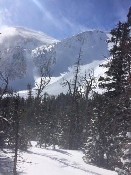
Yesterday morning the Bridger Range had 22” of powder with strong winds. This combination created avalanches, both natural and human triggered. I toured along the ridge, north of Bridger Bowl, and got shooting cracks in the wind slabs (video, photo); other skiers ventured into Wolverine Bowl and triggered a slide (photo); a snowboarder triggered a small wind pocket south of the ski area (video); a small natural avalanche broke on Saddle Peak (photo); and a large natural avalanche was seen near Fairy Lake (photo).
Winds have decreased and so will avalanche activity. I’m more concerned about someone getting caught in a slide today than yesterday because the red flags of shooting cracks, wind-loading and natural avalanches may be absent. It has been less than 24-hours since the winds lessened and wind slabs may still be unstable. Today the avalanche danger is a solid MODERATE on all wind-loaded terrain and LOW elsewhere.
Since Saturday, Cooke City has gotten 1.5-2 feet of snow. The only avalanches were point release, loose snow avalanches; nothing deeper. Ski guides reported windy conditions yesterday and had small wind slabs crack under their skis. Seven days ago Eric found a weak layer of faceted snow 2-3 feet deep (video), but it has not been active. This is good news, but I’m still reluctant to give non-wind-loaded slopes the bright green light. Partially it has to do with this layer, but the other part is that I’m gun shy because my confidence in the snowpack isn’t as solid as the other mountain ranges. For today, the avalanche danger is rated MODERATE on all slopes.
The Gallatin and Madison Ranges and the Lionhead area received 1-2 feet of snow since Saturday night along with wind. I rode into Lionhead on Sunday (video) and my concerns were limited to wind-loaded slopes. On all other slopes the snowpack is generally stable which Eric described in his video from Friday. The evidence for stability has been stacking up with concurring observations from Hyalite, around Big Sky, and in the southern Madison Range. There are no widespread weak layers in the snowpack. For today, the avalanche danger is MODERATE on wind-loaded slopes and LOW everywhere else.
If you get out and have any avalanche or snowpack observations to share, drop a line via our website, email (mtavalanche@gmail.com), phone (406-587-6984), or Instagram (#gnfacobs).
Upcoming Avalanche Education and Events
BOZEMAN
TONIGHT, Know Before You Go avalanche awareness, 7:00 p.m. @ Procrastinator Theater, MSU
March 2nd, Avalanche Awareness, 7-8:00 p.m., MAP Brewing Bozeman Split Fest
March 2nd and 3rd, SheJumps Companion Rescue Clinic, Info and Register HERE
March 3rd, Pinhead Classic at Bridger Bowl. Ski race, awards and legendary after party. Info HERE.
March 7th, Avalanche Awareness, 6-7:30 p.m. @ REI
LIVINGSTON
March 20, Beer for a Cause Night at Katabatic Brewing, 4-8p.m. A dollar from every pint will be donated to The Friends of the Avalanche Center.
COOKE CITY
Every Friday and Saturday, Current Conditions Update and Avalanche Rescue, Friday 6:30-7:30 p.m. at The Soda Butte Lodge in February. Saturday anytime between 10-2 @ Round Lake.
In Dashboard Talks, Episode 7, Alex Marienthal and Doug Chabot provide a few thoughts about why you should read the daily advisory. As the season wears on, don't get "Advisory Fatigue." There is a lot of winter still to come!


