Good Morning. This is Doug Chabot with the Gallatin National Forest Avalanche Forecast on Thursday, February 25th at 7:30 a.m. Today's forecast is sponsored by Uphill Pursuits and Spark R&D. This forecast does not apply to operating ski areas.
Yesterday morning the mountains around Bozeman and Big Sky picked up 1-2” of snow. Wind is west to southwest at 15-25 mph, except in the Bridger Range where it is gusting to 40 mph. Mountain temperatures are in the single digits F and will rise into the teens. Today will become mostly cloudy with snow showers and wind kicking in later this afternoon through Friday. Wind will be west to southwest at 20-35 mph and by morning 2-3” will have fallen.

In the Bridger Range 8” of new snow yesterday morning and 2” during the day all got blown around last night from strong west wind. It blew at all elevations and aspects and loaded slopes which could easily be triggered by a skier or rider. Shooting cracks are bulls-eye data of instability. Once a wind slab is released it could trigger a deeper slide on weak snow near the ground. A safe tactic is to stay off of wind-loaded terrain today. These freshly formed drifts might not be bonded to the underlying snow. The avalanche danger is rated CONSIDERABLE on all wind-loaded slopes and MODERATE on all others.

In the Gallatin and Madison Ranges and Lionhead area, the stability is getting better, but also a bit scarier. With time the snowpack is adjusting to last week’s snow load and triggering avalanches is becoming more difficult. It’s scarier because the weak snow at the ground (depth hoar) has avalanched deep and wide on a few slopes. These big slides, called Deep Slabs, are a bit of a nightmare. A person has low odds of triggering one and high odds of dying if they do. Our videos from 2 field days in McAtee Basin and Lionhead explain the possibility of triggering deep slab avalanches. Yesterday, ice climbers reported a wide and deep avalanche crown on the east face of Elephant Mountain in Hyalite; surprisingly wide and deep avalanches were triggered by Big Sky Snow Safety with explosives; plus deep avalanches on Mt Blackmore last week (video, photo), in Flanders Creek (photo) and around Lone Lake Cirque (photo). Last week’s 2-4 feet of snow with 3 days of strong wind almost doubled the depth of the snowpack in some areas. The weak, sugary snow at the ground is avalanching. The recent deep slab natural activity in tandem with avalanche control at the ski area getting wide and deep slides makes me sit up straight and pay attention. Deep slabs are here to stay. These can be triggered from thinner areas (3 feet or less) by the weight of a person.
For today the danger is rated MODERATE on all slopes because triggering avalanches is possible.
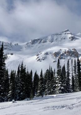
Ian just returned from 2 days in Cooke City where he saw a few slides on wind-loaded slopes (video). The avalanches on Mt. Henderson (photo), the shoulder of Mt. Abundance (photo) and a cornice triggered slide on Wolverine Peak (photo) all involved the new wind-drifted snow. It will remain possible to trigger slides on other wind-loaded slopes, so be wary if you see shooting cracks or notice waves of wind drifts. Also, a few isolated slopes have an unusually thin snowcover and/or rocky terrain are areas of weak snow where someone could trigger a slide. For today the avalanche danger is rated MODERATE on all slopes.
If you get out, please send us your observations no matter how brief. You can submit them via our website, email (mtavalanche@gmail.com), phone (406-587-6984), or Instagram (#gnfacobs).
The Beacon Park at Beall Park in Bozeman is running!
The Friends of the Avalanche Center in partnership with the City of Bozeman put in a Beacon Park at Beall Park. It is located on the north side of the Beall building between N. Bozeman Ave. and the ice rink. Stop by with your avalanche transceiver and do a few practice rescue drills. Your partner will thank you.
Upcoming Avalanche Education and Events
See our education calendar for an up-to-date list of all local classes. Here are a few select upcoming events and opportunities to check out:
Every Saturday in Cooke City, FREE snowpack update and rescue practice at the Round Lake Warming Hut between 10 a.m. and 3 p.m. Poster with More Info.
The US has reached 32 avalanche fatalities this season. With a lot of the avalanche season left we may reach 40 avalanche deaths for the first time since the winter of 1925-26. This is not a total we want to reach. A compilation of all avalanche fatality information can be found here.