Good Morning. This is Dave Zinn with the Gallatin National Forest Avalanche Forecast on Tuesday, January 5th at 7:15 a.m. This forecast is sponsored by Mystery Ranch and Cooke City Motorsports. This forecast does not apply to operating ski areas.
AVALANCHE WARNING
The Gallatin National Forest Avalanche Center is issuing a Backcountry Avalanche Warning for the Bridger Range, Southern Gallatin Range, Southern Madison Range, the Lionhead area near West Yellowstone and the Centennial Range near Island Park, ID. 8-10” of snow overnight with strong wind are overloading a weak snowpack, creating very dangerous avalanche conditions. Natural and human triggered avalanches are likely. Avalanche terrain and avalanche runout zones should be avoided. The avalanche danger is rated HIGH on all slopes. Contact the Gallatin National Forest Avalanche Center for more detailed information.
Website: www.mtavalanche.com
Avalanche Hotline: 406-587-6981
This warning will expire or be updated by 6:00 a.m. on Wednesday, January 6, 2021.
The Bridger, Madison, Southern Gallatin, Lionhead and Centennial Ranges received 8-10” of new snow, Cooke City got 6” and the Northern Gallatin Range received 4.” Winds are 15-30 mph from the west to south and temperatures are in the low 20s F. Snow will continue into the morning with the southern ranges picking up 2-3” and 1-2” in the northern areas. The wind will blow 15-20 mph from the west to southwest and temperatures will be in the 20s F.
Avalanche Warning
There is an Avalanche Warning in effect for the Bridger Range, Southern Gallatin Range, Southern Madison Range, the Lionhead area near West Yellowstone and the Centennial Range near Island Park, ID. Heavy snowfall overnight brought 8-10” of new snow with 0.8-1.0” of snow water equivalent (SWE). New snow and strong winds are overloading a weak snowpack and creating very dangerous avalanche conditions. Natural and human triggered avalanches are very likely.
Watch our recent videos from Lionhead, Taylor Fork and Saddle Peak to learn more about similarly weak snowpack structure in each of these areas.
Avalanche terrain and avalanche runout zones should be avoided. The avalanche danger is rated HIGH on all slopes.

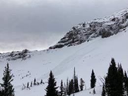
The Northern Madison Range received 9” of snow overnight with 0.6 SWE and the Northern Gallatin picked up 4” with 0.4 SWE. This snow is loading a weak foundation of sugary facets and sustained 25-35 mph winds from the southwest are creating unstable drifts that are likely to avalanche under the weight of a skier or rider. Recent avalanches in Hyalite Canyon are examples of what we are worried about triggering today (ice climber triggered avalanche details, natural avalanche details). With unusually strong winds, expect these unstable drifts to be in unusual locations. On Sunday, my partner and I did not witness any red-flags such as collapsing or recent avalanches in Beehive but we did find fistfuls of sugary facets near the bottom of the snowpack that failed in stability tests and are likely to produce avalanches under the weight of the new snow (video).
Cautious route finding, thorough snowpack assessment and conservative decision-making are essential today as human-triggered avalanches are likely. The danger is rated CONSIDERABLE.

Cooke City lacks the widespread weak layers of the other ranges in our advisory area. The avalanche danger increased with 6” of new snow overnight (0.6” SWE) and recently wind-drifted snow. Recent avalanches on Abiathar and Crown Butte are examples of the instabilities you should be assessing for and avoiding (photo and details, photo and details, video).
Carefully assess the snowpack by digging a snowpit and performing a stability test to see if you found an area with a weaker snowpack and avoid area of wind-drifted snow. The danger is rated MODERATE and human-triggered avalanches are possible.
If you get out, please send us your observations no matter how brief. You can submit them via our website, email (mtavalanche@gmail.com), phone (406-587-6984), or Instagram (#gnfacobs).
Upcoming Avalanche Education and Events
See our education calendar for an up to date list of all local classes. Here are a few select upcoming events and opportunities to check out:
Every Saturday in Cooke City, FREE snowpack update and rescue practice at the Round Lake Warming Hut between 10 a.m. and 3 p.m. Poster with More Info.
TONIGHT, 6-7 p.m. The Friends of the Avalanche Center will offer a FREE 1-hr Avalanche Awareness Talk in partnership with The Basecamp and Alpine Orthopedics and Sports Medicine. The talk will be a live, ONLINE event. Join us HERE.
Friday night and Saturday, January 8 & 9. The Friends of the Avalanche Center are teaching a Companion Rescue Clinic. Learn about avalanche terrain, weather, decision-making and rescue. Get more information and register HERE.
Monday, January 11, 6-7 p.m. The Friends of the Avalanche Center will offer a FREE 1-hr Avalanche Awareness Talk in partnership with Uphill Pursuits. The talk will be given via a live ZOOM session. Please click the link below to join the webinar: Join HERE.
Tuesday, January 19, 6-7 p.m. The Friends of the Avalanche Center will offer a FREE 1-hr Avalanche Awareness Talk in partnership with the University of Montana Western School of Outreach. The talk will be a live, ONLINE event. Join us HERE.
January 20 & 21 (plus field sessions the following weekends), Avalanche Fundamentals with Field Course. There are separate field sessions tailored for both skiers and splitboarders (Bridger Bowl) and snowmobilers (Buck Ridge). Register here.
A worthwhile read from Backcountry magazine: Four fatalities recorded in single weekend, amid “especially dangerous” avalanche conditions