Good Morning. This is Doug Chabot with the Gallatin National Forest Avalanche Forecast on Wednesday, December 23rd at 7:15 a.m. This forecast is sponsored by Summit Motorsports and Ski-Doo and Yellowstone Club Community Foundation. This forecast does not apply to operating ski areas.
In the last 24 hours snowfall stopped, winds decreased and temperatures dropped. The mountains around Bozeman and Big Sky picked up 5-7”, Cooke City got 4” and the mountains south of Big Sky to West Yellowstone received 1-2”. West to north winds subsided from gusts of 50+ to 10-30 mph this morning. Mountain temperatures will only reach the teens to low 20s under clearing skies. No snow is expected until the weekend.

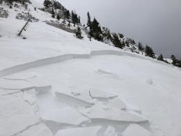
Strong, swirly winds at all elevations and 4 days of snowfall spiked the avalanche danger. Over 2 feet of snow fell (2.2” snow water equivalent - SWE) and yesterday there were many natural avalanches on wind-loaded slopes and a couple skier triggered slides, one breaking hundreds of feet wide (details). All were avalanching at the interface between the old and new snow (1-3’ deep). Ian and I are in Cooke City and saw a few of these and noted the instability in our snowpits (video). For today, check out the 5 entries for avalanche activity and look at the photos page to get a handle on the problem. Today is better stability than yesterday, but triggering slides is still likely on steep slopes, especially wind-loaded, and the danger is rated CONSIDERABLE. I do not expect many natural avalanches today, but skier and sledder triggered ones are a serious threat. Travel on at a time in avalanche runout zones and don’t let beautiful, sunny skies paint a false, rosy picture.
Lionhead received an inch of snow yesterday. Faceted, sugary grains of weak snow underlie the bottom 2 feet of a 3-foot snowpack. Snowfall on Sunday triggered natural avalanches and Dave and I were able to trigger 2 from low angled terrain 30’ and 75’ away (video, photo, photo). The snowfall has ended, but windblown snow is adding to the instability. Cracking, collapsing (whumpfs), and recent avalanches are signs to stay clear of steep slopes. Triggering slides on wind-loaded terrain is likely and the avalanche danger is rated CONSIDERABLE on wind-loaded slopes and MODERATE on all others.
The Bridger, northern Gallatin and northern Madison Ranges finally got snow: 5-7” (.5-.7” SWE). This was the largest storm since the season opener on October 11. Accompanying the snow was strong westerly wind. Avalanches are likely to be triggered on wind-loaded slopes and possible on steep, non-windloaded ones. The snowpack is weak and unstable. Sugary facets at the bottom ⅔ of the snowpack will struggle to support the new windblown snow (photo). For today, the avalanche danger is rated CONSIDERABLE on wind-loaded slopes and MODERATE on all others. A moderate danger is not a green light, it literally means it is possible to trigger slides.

The southern Madison and southern Gallatin Ranges got 1-2” yesterday with strong, gusty, west wind. The snowpack has a foundation of weak, sugary facets, but without significant loading since Friday its stability is improving. Dave and Alex rode into Taylor Fork on Monday and found poor snow structure and saw avalanche debris and crowns from Friday’s storm (video, photo, avalanche activity). Avalanches were breaking on the loose facets in the lower part of the snowpack and when snowfall resumes I expect to see more slides. Since the snowpack is weak and triggering avalanches is possible, the danger is rated MODERATE on all slopes.
If you get out, please send us your observations no matter how brief. You can submit them via our website, email (mtavalanche@gmail.com), phone (406-587-6984), or Instagram (#gnfacobs).
Upcoming Avalanche Education and Events
See our education calendar for an up to date list of all local classes. Here are a few select upcoming events and opportunities to check out:
Every Saturday in Cooke City, FREE snowpack update and rescue practice at the Round Lake Warming Hut between 10 a.m. and 3 p.m. Poster with More Info.
January 20 & 21 (plus field sessions the following weekends), Avalanche Fundamentals with Field Course. There are separate field sessions tailored for both skiers and splitboarders (Bridger Bowl) and snowmobilers (Buck Ridge). Register here.
There have been four avalanche fatalities in the mountains of CO and WY since Friday. We are deeply saddened by these events. You can find preliminary reports at https://avalanche.state.co.us/accidents/us/