Good Morning. This is Dave Zinn with the Gallatin National Forest Avalanche Forecast on Wednesday, April 1st at 7:15 a.m. Today’s forecast is sponsored by Grizzly Outfitters and Highline Partners.
Hyalite Canyon is now closed to vehicle traffic and will reopen on May 15th. This is the regular spring use closure. Bridger Bowl is closed and strongly advises against uphill travel which could place first responders at greater risk. Backcountry conditions exist. There is NO avalanche control or ski patrol rescue. Please do not loiter or congregate in the parking lots.
In the last 24 hours, the mountains received 10-13” of new snow. Winds were 10-20 mph from the west with strong gusts up to 65 mph at the Lulu Pass weather station. In the Bridger Range winds were 5-10 mph from the west. This morning mountain temperatures are in the upper single digits to mid-teens F. Today, high temperatures will be around 20 F, winds will be from the west at 10-15 mph before swinging northeast in the evening. There will be periods of partly cloudy skies this afternoon. By morning the southern ranges will get an additional 4-6” of snow with 2-4” in the northern ranges.

In the last two days, the mountains received 12-18” of new snow with 1.3-1.5” snow water equivalent (SWE) favoring the southern ranges. The mountains near West Yellowstone and Cooke City received nearly two feet of snow with 2” SWE. Strong gusts of wind built drifts of snow where human triggered avalanches are likely today. Recent avalanche activity and shooting cracks can indicate this instability. On many slopes, the new snow is adding stress to a weak layer buried 2-3’ deep. The weak layer has presented as a melt-freeze crust, feathery surface hoar crystals, and near-surface facets. We have found it on many slopes (but not all) and received reports of people triggering avalanches on this layer across our advisory area (avalanche activity, Lionhead and Taylor Fork video, Buck Ridge video). Choose to assess for this layer with a snowpit and stability test or choose to stay out of avalanche terrain.
Dangerous avalanche conditions exist today and human triggered avalanches are likely. Plan conservatively to minimize your time in and exposed to avalanche terrain and carefully assess the snowpack and route choices. The avalanche danger is CONSIDERABLE.

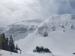
In the last two days, the Bridger Range received 13” of snow with 1.2” SWE with light 5-10 mph winds from the west. Small drifts exist near ridgelines and in isolated areas (photo) and are dangerous in technical terrain where they can push you into obstacles and cause trauma. Today, avalanches within the new snow and on weak layers buried 1-3 feet under the snow are the primary concern (Bridger video). Cool temperatures and clouds will minimize the wet snow danger today. However, do not underestimate how quickly stability can deteriorate if the sun pokes out this afternoon and the snow surface gets wet.
Human triggered avalanches are possible today. Use careful snowpack assessment and conservative terrain choices to minimize your exposure and respect the state’s stay-at-home directive by opting for mellow objectives close to home. The avalanche danger is MODERATE.
We plan to end daily avalanche forecasts on Sunday, April 5th and continue with general bulletins every Monday and Friday through April. We have taken down most weather stations and will no longer receive observations from guides and ski patrol. We need help gathering field data. Please send us your observations no matter how brief. You can fill out an observation form, email us (mtavalanche@gmail.com), leave a VM at 406-587-6984, or Instagram (#gnfacobs).
Backcountry Skiing and Stay-at-home Order
A Stay at Home order is in effect for the State of Montana due to COVID-19. This order specifically discourages “outdoor recreation activities that pose enhanced risks of injury or could otherwise stress the ability of local first responders to address the COVID-19 emergency (e.g., backcountry skiing in a manner inconsistent with avalanche recommendations or in closed terrain)”.
Please slow down and consider mellower terrain to reduce the potential for injury or a rescue. Also, consider that the distraction of current events may cloud our judgment which compromises our ability to safely attempt more challenging objectives. Take a step back. Ride Safe.
Park county is requesting anyone who is not a permanent resident or provider of essential service avoid all travel to Cooke City/Silvergate. This includes both single day and overnight visitors.
Avalanche Education
See our calendar for a couple live online avalanche courses being offered this week.
A recent avalanche in Colorado left a rider with life-threatening injuries, required extensive resources and put rescuers at high risk. Read this article from Outside Magazine about the event, and please adjust your travel habits to respect and conserve our community’s resources.