Good Morning. This is Alex Marienthal with the Gallatin National Forest Avalanche Forecast on Monday, March 30th at 7:00 a.m. Today’s forecast is sponsored by Mystery Ranch and Klim Gear.
Bridger Bowl is closed and strongly advises against uphill travel which could place first responders at greater risk. Backcountry conditions exist. There is NO avalanche control or ski patrol rescue. Please do not loiter or congregate in the parking lots.
Park county is requesting anyone who is not a permanent resident or provider of essential service avoid all travel to Cooke City/Silvergate. This includes both single day and overnight visitors.
This morning the mountains near West Yellowstone, Cooke City and Big Sky have 1-2” of snow. Elsewhere there is no new snow. Yesterday southwest wind gusted 20-30 mph then decreased overnight. This morning temperatures are 20s to low 30s F with southwest wind at 5-15 mph. Today temperatures will reach high 30s to low 40s F under partly sunny skies. Southwest wind will increase this afternoon to 20-30 mph. Light snow showers are possible today with more snow tonight through Wednesday. By tomorrow morning 3-5” of snow is possible near West Yellowstone and Cooke City with 1-3” elsewhere.

All Regions
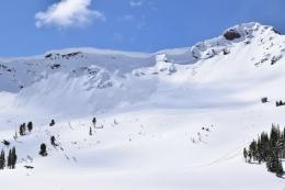
Yesterday a snowmobiler triggered a slide on Buck Ridge when he descended to help another stuck rider, nobody was caught (photo and details). The slide broke a foot deep on the crust below last week’s snow. Several slides broke on this layer last week (photo, photo, weather and avalanche log). Over the weekend we received reports of consistent unstable test scores on this layer, including our own findings in Taylor Fork and Lionhead (video). Today avalanches are possible to trigger, breaking above and sliding on the crust 1-2 feet deep. Dig down a couple feet to assess snow stability. Avoid steep slopes where you find a slab of snow sitting on top of a crust.
Yesterday’s sun and warm temperatures caused small wet loose avalanches and cornice fall triggered avalanches. We got reports of these in the northern Bridger Range (photo) and Hyalite (photo). Today warm temperatures and some sun make wet avalanches and cornice falls possible. Avoid steep slopes where the snow surface gets moist or wet, and be cautious of steep, rocky terrain above you where natural wet avalanches might initiate (photo). Cornices can break further back than expected, and possibly trigger large avalanches. Stay far back from cornices along ridgelines and avoid slopes directly below (photo).
Areas that received a few inches of snow last night are forecast to be cloudier with more snow this afternoon. I expect minimal wet snow there, but even brief clear skies will make wet slides possible. Increasing wind and possibly more snow this afternoon will form fresh drifts. Avoid these slabs which may be large enough to bury a person or can push you into hazards like trees, rocks or over cliffs.
Today heightened avalanche conditions exist and avalanches are possible. Carefully evaluate the snowpack and make conservative choices. Avalanche danger is rated MODERATE.
We plan to end daily avalanche forecasts on Sunday, April 5th and continue with general bulletins every Monday and Friday through April. We have taken down most weather stations and will no longer receive observations from guides and ski patrol. We need help gathering field data. Please send us your observations no matter how brief. You can fill out an observation form, email us (mtavalanche@gmail.com), leave a VM at 406-587-6984, or Instagram (#gnfacobs).
Backcountry Skiing and Stay-at-home Directive
Please consider mellower terrain and lowering your risk to reduce potential for a needed rescue. Also, consider that the distraction of current events may cloud our judgment which compromises our ability to safely attempt more challenging objectives. Take a step back. Ride Safe.
A Stay at Home order is in effect for the State of Montana due to COVID-19. This order specifically discourages “outdoor recreation activities that pose enhanced risks of injury or could otherwise stress the ability of local first responders to address the COVID-19 emergency (e.g., backcountry skiing in a manner inconsistent with avalanche recommendations or in closed terrain)”. Get out and enjoy the fresh air, but please dial back your objectives, slow down, and work to minimize the risk of injury or need for rescue.
A recent avalanche in Colorado left a rider with life-threatening injuries, required extensive resources and put rescuers at high risk. Read this article from Outside Magazine about the event, and please adjust your travel habits to respect and conserve our community’s resources.