Good Morning. This is Doug Chabot with the Gallatin National Forest Avalanche Forecast on Thursday, March 26th at 7:15 a.m. Today’s forecast is sponsored by Bridger Bowl and Gallatin County Search and Rescue.
Bridger Bowl parking lots are private property. Please do not loiter, camp overnight or congregate in the parking lots. Please skin, ski, and leave. The ski area is closed, snowmobiles are not allowed, and backcountry conditions exist (video).
COVID-19 cases in Gallatin County: 24 @ 4:30 p.m. yesterday.
In the last 24 hours Cooke City, Hyalite and Big Sky received 5-6” while everywhere else got 2-3”. Wind has been westerly at 5-10 mph with gusts of 20 mph. Skies are clearing this morning but will remain partly cloudy in the southern ranges. Wind will remain light and mountain temperatures may rise into high 30s. No snow is expected in the next few days.

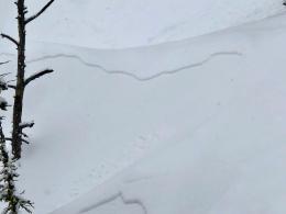
In the last 2 days the northern mountains received 18” around Big Sky and 9-12” everywhere else measuring around 1” snow water equivalent (SWE). There have been avalanches in the new snow. Yesterday in the Bridger Range skiers noted small slides breaking within the new snow (photo) and on the ice crust which underlies this week’s accumulation. Also, near Hyalite Peak, skiers saw debris from a small natural avalanche that broke 12” deep in the new snow.
The new snow is sitting on an ice crust on many aspects and elevations. As Dave and I discovered during our tour at Bridger Bowl on Tuesday, avalanches could be triggered on this crust (video). This will become especially problematic as skies clear and strong sunshine dampens the snow and triggers many loose, wet, point release avalanches that will slide far on this hard layer. Be extra careful about triggering slides if people are below you. No matter if you are on a sled or skis avoid avalanche terrain once the new snow gets wet.
The avalanche danger is rated MODERATE on all slopes this morning, but will rise to CONSIDERABLE for wet avalanches by this afternoon on slopes getting direct sunshine.

In the southern ranges, Cooke City has gotten 15” in the last 48 hours while 8-9” fell around West Yellowstone and Taylor Fork (.6-1” SWE). An ice crust of varying thickness underlies the new snow on many slopes. Avalanches are possible on this crust, no matter if they are new snow slides, slabs from wind-loading, or wet snow. Concentrate your stability assessment on the upper 2 feet of the snowpack, crust or not, since this is where instability will be found. Dave and I made a video during our tour in the Bridger Range that is also applicable to the southern mountains.
Skies are forecasted to be partly cloudy with mountain temperatures reaching the low 30s. This will help keep wet avalanche activity from becoming widespread. The snow will dampen with direct sunshine and skiers and sledders should be on the lookout for pinwheels in the new snow, a sign that the surface is getting wet enough to avalanche.
Given the new snow, underlying crusts and potential for a few wet avalanches, the danger is rated MODERATE on all slopes.
We will end daily avalanche forecasts on Sunday, April 5th and continue with general bulletins every Monday and Friday through April. Over the next couple of weeks, we will take down weather stations and will no longer receive observations from guides and ski patrol. We need help gathering field data. Please send us your observations no matter how brief. You can fill out an observation form, email us (mtavalanche@gmail.com), leave a VM at 406-587-6984, or Instagram (#gnfacobs).
COVID-19 Info and Updates
This Montana map is updated with the latest infection and fatality numbers every 8 a.m. and 4:30 p.m.
Gallatin County Health Department and the Montana Department of Health and Human Services website has up-to-date information on all things virus related.
We hope all can enjoy the outdoors to ease the stress during this challenging time. We will continue regular avalanche forecasts until April 5th. It is important we all do our part to reduce the spread of COVID-19 in our community. While you are in parking lots and on trails please practice social distancing and other precautions recommended by the city, county and CDC (video from county health department). Please do not carpool with people outside your household, keep groups small and don’t have social gatherings in the parking lot (with dogs as well). Be patient and courteous. Step aside for other groups to pass. Smile, communicate, say hi, “go ahead” and “thank you”. Dial back your objectives and slow down to minimize the risk of injury and overtaxing local EMS services. Help each other and stay safe. Thank you.
Upcoming Avalanche Education and Events
The Friends of the GNFAC provides free and low-cost avalanche education in Southwest Montana (and beyond). This year our fantastic group of instructors reached OVER 4000 individuals with our programs!
Thank you to our team and thank you to everyone in the community for valuing safe backcountry recreation!
You can find courses offered by other providers on our website on the Events and Education Calendar.
To slow the spread of novel coronavirus do the FIVE: 1) HANDS Wash them often. 2) ELBOW Cough into it. 3) FACE Don't touch it. 4) SPACE Keep safe distance. 5) HOME Stay if you can.