Good Morning. This is Alex Marienthal with the Gallatin National Forest Avalanche Forecast on Sunday, January 26th at 7:00 a.m. Today’s forecast is sponsored by Gallatin Valley Snowmobile Association and Alpine Orthopedics. This forecast does not apply to operating ski areas.
Since yesterday the mountains near Cooke City got 3” of snow, near West Yellowstone got 1” and elsewhere got zero. This morning temperatures are high teens to mid-20s F and wind is westerly at 5-20 mph. Today temperatures will be high 20s to low 30s F with west wind at 5-20 mph. Snow is expected this afternoon near West Yellowstone and throughout the forecast area tonight. By morning the mountains will have 3-7” of new snow.

All Regions
Weak layers near the base of the snowpack are at least 2-4 feet deep and make large avalanches possible to trigger. The last reported human triggered avalanches in the backcountry were six days ago (details, details). Over the last week the mountains got a few inches of snow equal to 0.5-0.7” of snow water equivalent (SWE) with 1” SWE near Cooke City. Deeply buried weak layers can adjust to this small addition of weight, but they remain close to breaking under the weight of a human or cornice fall. I wrote this mid-season snowpack summary to review the current poor snowpack structure and recent large avalanches.
It has become more difficult to trigger a huge avalanche on sugary snow near the ground, but the consequences are large and call for conservative travel. We have seen fewer signs of instability, such as collapsing and cracking, but large skier and snowmobiler triggered avalanches last weekend are fresh in memory. See our photos page for a look at large avalanches last weekend.
Recent warning signs are not entirely absent. On Thursday skiers north of Bridger Bowl had a slope collapse which sent them home for clean underwear (details). On Friday the Big Sky ski patrol used explosives to trigger a deep avalanche on weak snow near the ground (details and photos). Yesterday a skier saw a recent natural avalanche on Alex Lowe peak in Hyalite (photo). We continue to find and get reports of unstable extended column test scores even where weak layers are buried very deep.
Avalanches can break deep and wide on weak layers near the ground if a trigger hits the right spot. Avoid heavily wind loaded slopes, where large slides can be triggered from thinner areas of the snowpack (video). Carefully assess snowpack and terrain before riding on or under steep slopes. If you see a poor snowpack structure or expect a bad outcome, then find lower angle terrain.
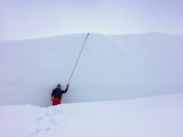
On Friday I was at Mt. Ellis where the snowpack is the shallowest in our advisory area (video). It looked like much of our forecast area did at the start of December. When a supportable slab forms from new or wind-drifted snow large avalanches will be easy to trigger.
Today, large avalanches are possible to trigger and avalanche danger is MODERATE.
If you get out, please send us your observations no matter how brief. You can fill out an observation form, email us (mtavalanche@gmail.com), leave a VM at 406-587-6984, or Instagram (#gnfacobs).
King and Queen of the Ridge at Bridger Bowl
Next Saturday, February 1, is the King and Queen of the Ridge at Bridger Bowl! Come up and help us raise money by hiking and skiing laps on the ridge. Prizes, camaraderie and a good time are guaranteed. Register with Bridger to hike in the event and create a pledge page to raise funds with your Ridge laps.
Upcoming Avalanche Education and Events
Our education calendar is full of awareness lectures and field courses. Check it out and plan to attend one or two: Events and Education Calendar.
COOKE CITY
Every Friday and Saturday, Snowpack Update and Rescue Training. Friday, 6:30-7:30 p.m. at the Soda Butte Lodge. Saturday anytime between 10-2 @ Round Lake.
BOZEMAN
January 27, Avalanche Information and Demonstration Table, 10 a.m. to 12 p.m. at Montana Science Center.
January 29, GNFAC Forecaster Chat: Avalanche Myth Busters, 6-8 p.m. at Uphill Pursuits.
January 31, Women’s Only Companion Rescue Clinic, 6 - 8 pm at REI followed by a field day February 1. More info and Register Here.
February 1, King and Queen of the Ridge at Bridger Bowl (fundraiser). This is the Friends of the Avalanche Center’s second biggest fundraiser of the year. Help us raise money by hiking and skiing laps on the ridge. Prizes, camaraderie and a good time is guaranteed. Register with Bridger to hike in the event, and create a pledge page to raise funds with your Ridge laps.
DILLON
January 29 and 30, Introduction to Avalanche w/ Field Course, evenings of January 29 & 30 plus a field day February 1. Snowmobile specific field day offered February 2. More Info and Register Here.
WEST YELLOWSTONE
February 1, 1-hr Avalanche Awareness, 7-8 p.m. at West Yellowstone Holiday Inn.
HELENA
January 28, 1-hr Avalanche Awareness, 6-7 p.m. Carroll College.
LIVINGSTON
January 30, Introduction to Avalanche w/ Field Course, evening of January 30 plus a field day February 2. More info and Register Here.
See our mid-season snowpack summary for a review of the deep slab avalanche problem and general (conservative) travel advice.