Good Morning. This is Dave Zinn with the Gallatin National Forest Avalanche Forecast on Tuesday, January 21st at 7:00 a.m. Today’s forecast is sponsored by Highline Partners and Gallatin County Search and Rescue. This forecast does not apply to operating ski areas.
The southern ranges received 1-2 inches of snow last night, the northern ranges remained dry. Temperatures are in the 20s F and winds are 10-20 mph from the southwest with gusts of up to 45 mph in Hyalite Canyon. Temperatures in the northern mountains will rise into the 40s F with slightly cooler conditions in the southern ranges and winds will be 10-30 mph from the southwest. The mountains around West Yellowstone and Cooke City will get 2-4” of new snow by morning and the northern ranges will get a trace to 2”.

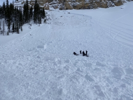
This weekend skiers, riders, new snow, and cornice falls triggered seventeen avalanches in the Bridger and Madison Ranges, and the mountains around Cooke City and West Yellowstone. There were two close calls yesterday when snowmobilers unintentionally triggered avalanches that broke on deeply buried weak layers in the Buck and Lionhead Ridge areas (avalanche activity). The rider in Lionhead stated, " Our group is trained in avalanche safety, practiced beacon use prior to leaving town in the morning, were wearing avalanche gear, and were very fortunate that this ended the way it did" (avalanche activity). We added these incidents to our avalanche log that includes a 10-foot deep snowmobile triggered slide on Cedar Mountain (details), a skier triggered avalanche north of Bridger Bowl (details), and natural avalanches near Lionhead Ridge and Cooke City (photo, avalanche activity). We are grateful to everyone who sent in their incident reports this weekend. You help us learn and make safer decisions as a community.
Human triggered avalanches are less likely each day without new snow. Many riders or skiers will “get away with it” before an unlucky person triggers a potentially fatal avalanche. This is the reality of moderate danger on a year with widespread persistent weak layers as Alex and I discuss in our video. Doug explains in his video from Mount Abundance that thinner areas in the snowpack are the likely places a skier or rider can trigger one of these monster avalanches. The management strategy is avoiding steep terrain and an honest assessment of your personal risk tolerance. The avalanche danger is rated MODERATE with large, human triggered avalanches possible.
The Shower Falls Snotel reported only 10” of new snow in the last week, but wind gusts of up to 65 mph were enough to build large, dense slabs of snow. On Saturday, skiers unintentionally triggered three separate avalanches in the Northern Gallatin Range, the largest broke up to 7 feet deep on buried weak layers (details, details, details). These were the first large slides of the year reported in this area. Yesterday on a tour to Divide Peak, we found a generally stable snowpack outside of areas with heavy wind loading (video). Give fresh drifts of snow time to stabilize by avoiding steep slopes loaded by the wind. Assess the snowpack and consequences of a small avalanche before committing to steep terrain. The avalanche danger is rated MODERATE on wind loaded slopes and LOW everywhere else.
If you get out, please send us your observations no matter how brief. You can fill out an observation form, email us (mtavalanche@gmail.com), leave a VM at 406-587-6984, or Instagram (#gnfacobs).
Upcoming Avalanche Education and Events
Our education calendar is full of awareness lectures and field courses. Check it out and plan to attend one or two: Events and Education Calendar.
COOKE CITY
Every Friday and Saturday, Snowpack Update and Rescue Training. Friday, 6:30-7:30 p.m. at the Soda Butte Lodge. Saturday anytime between 10-2 @ Round Lake.
BOZEMAN
January 27, Avalanche Information and Demonstration Table, 10 a.m. to 12 p.m. at Montana Science Center.
January 29, GNFAC Forecaster Chat: Avalanche Myth Busters, 6-8 p.m. at Uphill Pursuits.
January 31, Women’s Only Companion Rescue Clinic, 6 - 8 pm at REI followed by a field day February 1. More info and Register Here.
February 1, King and Queen of the Ridge at Bridger Bowl (fundraiser). This is the Friends of the Avalanche Center’s second biggest fundraiser of the year. Come on out and help us raise money by hiking and skiing laps on the ridge. Prizes, camaraderie and a good time is guaranteed. Register with Bridger to hike in the event, and create a pledge page to raise funds with your Ridge laps.
DILLON
January 29 and 30, Introduction to Avalanche w/ Field Course, evenings of January 29 & 30 plus a field day February 1. Snowmobile specific field day offered February 2. More Info and Register Here.
WEST YELLOWSTONE
January 25, 1-hr Avalanche Awareness, 7-8 p.m. at West Yellowstone Holiday Inn.
February 1, 1-hr Avalanche Awareness, 7-8 p.m. at West Yellowstone Holiday Inn.
HELENA
January 28, 1-hr Avalanche Awareness, 6-7 p.m. Carroll College.
LIVINGSTON
January 30, Introduction to Avalanche w/ Field Course, evening of January 30 plus a field day February 2. More info and Register Here.
In the last week, there were five avalanche fatalities in the U.S., in Oregon, Idaho, Utah, California, and Colorado. This season there have been 12 avalanche fatalities (More info). We are deeply saddened by each of these events. The snowpack throughout the western U.S. buried weak layers that have been overloaded by storms since the start of 2020. Ride safe.