Good Morning. This is Alex Marienthal with the Gallatin National Forest Avalanche Forecast on Monday, December 30th at 7:00 a.m. Today’s forecast is sponsored by Your Montana Chevy Dealers and Alpine Orthopedics. This forecast does not apply to operating ski areas.
Yesterday 1-2” of very low density snow fell near Bozeman and Big Sky, and elsewhere got no snow. This morning temperatures are single digits to low teens F. Wind is out of the northwest-northeast at 0-10 mph with gusts to 15 mph. In the Bridger Range wind is 5-15 mph with gusts to 25 mph at the ridgeline and downhill mid-mountain. Today will be partly sunny with temperatures in the teens to low 20s F and northerly wind at 5-15 mph. New snow is on tap for the New Year starting tomorrow night through Thursday morning.

Over the last month, several large natural and human triggered avalanches occurred near Cooke City (photos, activity log). These avalanches broke deep and wide on heavily wind loaded slopes that have weak snow at the base of the snowpack. Yesterday Dave and Doug investigated a few snowmobile triggered slides that happened Friday. Their video and photos show the type of steep, heavily wind loaded terrain to avoid in order to avoid invovelment with a similar deadly avalanche. Carefully evaluate the terrain and snowpack before riding on steep slopes. Today large avalanches are possible to trigger and avalanche danger is MODERATE.
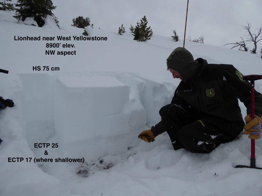
Near Big Sky and West Yellowstone buried weak layers had time to adjust to the weight of previous storms. This has helped the snowpack gain stability, but the poor snowpack structure needs more time (video). Avalanches are more difficult to trigger, but can break 2-3 feet deep on weak sugary snow near the ground (photo, photo). Warning signs like natural avalanches and collapsing are unlikely. Avoid avalanche terrain, or carefully evaluate the snowpack and terrain before riding steep slopes. Large human triggered avalanches are possible and avalanche danger is MODERATE.

In the Bridger Range, moderate mid-mountain wind created fresh drifts from the recent low density snow. These drifts are small, but can be triggered in less common locations at lower, mid-mountain elevations. Otherwise, in the mountains near Bozeman the snowpack is generally stable and instabilities are confined to the recent few inches of very low density snow. I skied near Fairy Lake yesterday and saw a thin, stable snowpack and small natural dry loose avalanches (video). Today be on the lookout for fresh drifts and dry loose avalanches. Avoid terrain where the consequences of a slide increase due to hazards like cliffs or trees, like a lot of the terrain on Saddle Peak. Small avalanches can be triggered today, otherwise larger avalanches are unlikely and avalanche danger is LOW.
If you get out, please send us your observations no matter how brief. You can fill out an observation form, email us (mtavalanche@gmail.com), leave a VM at 406-587-6984, or Instagram (#gnfacobs).
Upcoming Avalanche Education and Events
Our education calendar is full of awareness lectures and field courses. Check it out and plan to attend one or two: Events and Education Calendar.
COOKE CITY
Every Friday and Saturday, Snowpack Update and Rescue Training. Friday, 6:30-7:30 p.m. at the Soda Butte Lodge. Saturday anytime between 10-2 @ Round Lake.
WEST YELLOWSTONE
January 4, 1-hr Avalanche Awareness, 7-8 p.m. at West Yellowstone Holiday Inn.
January 25, 1-hr Avalanche Awareness, 7-8 p.m. at West Yellowstone Holiday Inn.
BOZEMAN
January 7, Women's Specific Avalanche Awareness + Beacons, 6-8 p.m. at Story Mill.
January 8, 1-hr Avalanche Awareness, 6-7 p.m. at REI.
January 8, 1-hr Avalanche Awareness, Gallatin Valley Snowmobile Association Groomer Building.
January 10 & 11, Companion Rescue Clinic, 6-8 p.m. on the 10th at REI and 10-2 p.m. on the 11th at History Rock. More info and Register Here.
January 15 and 16, Introduction to Avalanche w/ Field Course, evenings of January 15 & 16 plus one field day either January 18, 19 or 25. Snowmobile specific field day offered January 25. More info and Register Here.
The Lionhead Weather Station is up and running! You can access the data here.