Good Morning. This is Alex Marienthal with the Gallatin National Forest Avalanche Forecast on Monday, December 23rd at 7:00 a.m. Today’s forecast is sponsored by Bridger Bowl and Montana State Parks. This forecast does not apply to operating ski areas.
Yesterday's extreme south-southwest winds decreased overnight to 15-30 mph with gusts of 40-50 mph. This morning there is no new snow. Temperatures are high 20s to mid-30s F and will remain in that range today. Wind will be southwest at 15-30 mph. Snow will arrive tonight near West Yellowstone, Cooke City and south of Big Sky, and tomorrow morning near Bozeman and Big sky. By morning the mountains near West Yellowstone will get 2-4” of snow with 8-12” possible through tomorrow. Elsewhere will get 2-3”.

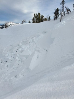
Yesterday Doug and I went to Lionhead Ridge near West Yellowstone and found a snowpack capable of producing large avalanches (video). Sugary, weak snow near the ground below a foot of dense snow creates a poor snowpack structure (photo). Dave was in Beehive Basin where he found a more stable, but weak snowpack (video). The mountains have not received more than a couple inches of snow the last nine days, and the snowpack had time to gain stability. This means signs of instability such as recent avalanches and collapsing are scarce, but it is possible to trigger a large avalanche.
Yesterday below Lionhead Ridge we snowmobiled under a couple large avalanche paths. We stayed far away in the flats of the runout zone and exposed only one person a time. You don’t have to be on the steep part of a slope to trigger an avalanche. Today practice cautious route finding and conservative terrain selection. Avalanche danger is MODERATE.
In the mountains near Cooke City, avalanche activity from the past week shows a snowpack capable of producing large avalanches. Over the weekend, skiers south of Cooke City saw a large natural avalanche that broke on weak snow near the base of the snowpack (photo). A large natural avalanche last weekend was on a similar aspect and elevation (NE, 9,800’) (photo). Additionally, last weekend snowmobilers triggered several large slides that broke on weak snow a couple feet deep (incident, photo). We visited Cooke City last week and found these buried weak layers on many slopes (photo, video). Study our Cooke City regional page to see types of terrain where these instabilities exist, and avoid slopes where you suspect buried weak layers. Today large human triggered avalanches are possible and danger is MODERATE.

Near Bozeman unstable snow is isolated to slopes where extreme southwest winds over the weekend built hard drifts on top of weak snow. On Saturday riders triggered two avalanches 3-5 feet deep on heavily wind loaded slopes (photo, photo). Yesterday Ice climbers in Hyalite had a freshly drifted hard slab collapse, crack and “whumph” on their approach (activity). These hard slabs will gain stability today, but deserve caution. Identify them as hard pillows of snow which may sound hollow or like a drum. Avalanches may be triggered on isolated slopes where hard slabs formed over weak snow. Otherwise the snowpack is generally stable and avalanche danger is LOW.
If you get out, please send us your observations no matter how brief. You can fill out an observation form, email us (mtavalanche@gmail.com), leave a VM at 406-587-6984, or Instagram (#gnfacobs).
Upcoming Avalanche Education and Events
Our education calendar is full of awareness lectures and field courses. Check it out and plan to attend one or two: Events and Education Calendar.
BOZEMAN
15 & 16 January, Introduction to Avalanche w/ Field Course, Evenings of January 15 & 16 plus one field day either January 18, 19 or 25. Snowmobile specific field day offered January 25. More info and Register Here.
COOKE CITY
Every Friday and Saturday, Snowpack Update and Rescue Training. Friday, 6:30-7:30 p.m. at the Soda Butte Lodge. Saturday anytime between 10-2 @ Round Lake.
WEST YELLOWSTONE
January 4, 1-hr Avalanche Awareness, 7-8 p.m. at West Yellowstone Holiday Inn.
The Utah Avalanche Center has posted the full accident report from last Sunday’s avalanche fatality near Park City. The report is available HERE.