This is Alex Marienthal with the Gallatin National Forest Avalanche Forecast on Monday, December 9th at 7:00 a.m. Today’s forecast is sponsored by Gallatin County Search and Rescue and Yellowstone Ski Tours. This forecast does not apply to operating ski areas.
The mountains got 4-6” of snow before the storm ended mid-day yesterday. Yesterday afternoon wind was west-northwest at 20-30 mph with gust to 45 mph. This morning wind is westerly at 5-15 mph and temperatures are single digits to teens F. Today will be partly cloudy with temperatures in the mid-teens to low 20s F and west-northwest wind at 10-20 mph. The next chance for significant snow is Wednesday.

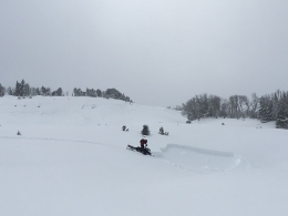
Yesterday on Lionhead Ridge near West Yellowstone skiers triggered large collapses of the snowpack on low angle terrain (photo), and on Buck Ridge near Big Sky snowmobilers saw widespread natural avalanches that broke on sugary weak snow near the ground (photo, photo). During yesterday’s storm the mountains near Big Sky and West Yellowstone got 8-10” of snow equal to 0.7-0.9” of snow water equivalent (SWE). Moderate to strong westerly wind drifted this snow into thick slabs which overloaded an unstable snowpack (photo, video). Today dangerous avalanche conditions exist and large avalanches are easy to trigger. The poor snowpack structure makes it possible to trigger avalanches from low angle terrain below steep slopes. Avoid travel on and underneath steep slopes. Avalanche danger is CONSIDERABLE.
Yesterday near Cooke City two separate snowmobilers had close calls with avalanches (details here). One triggered a small slide which buried his sled (but not him) in a terrain trap and he had to be rescued. The other was near Crown Butte attempting to ascend the steep north side of Daisy Pass when a natural avalanche released and nearly missed their group. Yesterday the mountains near Cooke City got 14” of snow equal to 1.4” of SWE. Strong westerly wind drifted this heavy snow into thicker, heavier slabs which remain easy to trigger. Today, large avalanches are easy to trigger and avalanche terrain should be avoided, especially wind-loaded slopes. Avalanche danger is CONSIDERABLE.

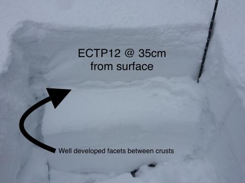
The Bridger Range and Hyalite got 4-6” of new snow equal to 0.5-0.6” of SWE during yesterday’s storm. Avalanches breaking below this new snow are possible where westerly wind formed fresh drifts. Yesterday skiers in the northern Bridger Range found unstable stability test results on weak layers a foot below the snow surface (photo). The new snow is not quite enough to create widespread instability on these weak layers, but it is worthwhile to search for these layers and avoid steep slopes where they exist. We are suspect of these buried weak layers on Saddle Peak where hard wind slabs formed above them (photo, video). Carefully assess the stability of recent snow and be extra cautious of wind loaded slopes. Today the avalanche danger is MODERATE.
Backcountry Barriers Contest
Click here to learn more about the Backcountry Barriers Contest: 1.shortstack.com/NLfNvh
We recognize that backcountry skiing can be daunting. That’s why Ben Goertzen and the Friends of the Gallatin National Forest Avalanche Center have teamed up to help breakdown some of the most prominent barriers of entry to backcountry skiing through this campaign. One lucky winner will be given a complete backcountry skiing kit, a spot in an avalanche awareness course, and featured in a three part video series that ends with an excursion into the backcountry with professional skier and filmmaker, Ben Goertzen. These videos will be used by the Friends of GNFAC to help other aspiring backcountry skiers gain awareness, knowledge and start to breakdown their barriers to entry.
Upcoming Avalanche Education and Events
Our education calendar is full of awareness lectures and field courses. Check it out and plan to attend one or two: Events and Education Calendar.
BOZEMAN
December 11, 1-hr Avalanche Awareness, 6-7 p.m. at REI.
December 12, Avalanche Awareness + Beacon Practice, 6-8 p.m. at Story Mill Community Center.
WEST YELLOWSTONE
9 & 10 December, Snowmobile/Ski Introduction to Avalanche w/ Field Course, 12-5p Dec 9 and field day Dec 10. More info and Register Here.
MANHATTAN
December 9, 1-hr Avalanche Awareness, 7-8 p.m. at Manhattan High School.
COOKE CITY
Every Friday and Saturday, Snowpack Update and Rescue Training. Friday, 6:30-7:30 p.m. at the Soda Butte Lodge. Saturday anytime between 10-2 @ Round Lake.
Sadly, yesterday in Colorado a skier was buried and killed in an avalanche. This is the first avalanche fatality this season in the U.S. CAIC preliminary report.