Good morning. This is Doug Chabot with the Gallatin National Forest Avalanche Forecast issued on Saturday, April 6th at 6:30 a.m. Today's forecast is sponsored by Yellowstone Arctic Yamaha in partnership with the Friends of the Avalanche Center. This forecast does not apply to operating ski areas.
Freezing line fluctuated between 7,500-8,500 feet, the elevation of many weather stations making snowfall amounts difficult to determine. It is estimated that 3” fell in the Bridger Range, 1” at Big Sky and 5” around Taylor Fork, West Yellowstone and Cooke City. Winds are west to southwest at 15-25 mph with mountain temperatures of 25-33F. This morning a passing front will bring drizzle to the low elevations and 1-2” of snow up high. Skies will clear this afternoon and temperatures will rise to 40F.

All Regions
Today’s avalanche equation is simple:
Frozen = Good
Unfrozen = Bad
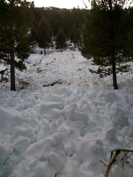
It rained in the mountains and rain weakens the snow quickly. The rain/snow line fluctuated range-to-range and hour-to-hour. Freezing temperatures last night made a crust on most slopes, but this will quickly break down with warm temperatures. At higher elevations, snowfall likely tops 5” since .5-.7” of snow water equivalent fell.
Sun will end up being the deciding factor for wet avalanches. Since the snowpack is wet at the lower elevations a little sun will quickly melt crusts. At higher elevations direct solar radiation will trigger loose-wet avalanches in the new snow. Snow becomes unstable with rapid change and in the last 24 hours it has been hit with rain, snow, freezing and melting. As soon as you find the snow surface to be wet it is time to head home. Pinwheels rolling downhill in the new snow or sinking past your boot tops in wet snow are signs of increasing avalanche danger.
If you leave early for the higher elevations you’ll likely find dry snow and good skiing or riding. Isolated wind slabs at the ridgelines along with large cornices are the main avalanche concern on these upper slopes.
For today, given the recent rain, snow, wind, fluctuating freezing line and potential sunny skies, the avalanche danger is rated MODERATE since both dry and wet snow avalanches are possible. Today is a day to be nimble in your thinking and route-planning since there are more variables than normal in determining stability. The fallback position is that wet snow is bad.
If you get out and have any avalanche or snowpack observations to share, contact us via our website, email (mtavalanche@gmail.com), phone (406-587-6984), or Instagram (#gnfacobs).
The Hyalite road is closed to motorized travel until May 16th. Bike and foot traffic is allowed.