Good morning. This is Alex Marienthal with the Gallatin National Forest Avalanche Forecast issued on Monday, March 25th at 7:00 a.m. Today's forecast is sponsored by World Boards and Yellowstone Club Community Foundation. This forecast does not apply to operating ski areas.
Last night the mountains near Cooke City received 6” of snow, 2-3” fell near Big Sky and Hyalite, and a trace to 1” fell in the Bridger Range and near West Yellowstone. This morning temperatures range from high teens to high 20s F under mostly cloudy skies, and wind is southwest at 5-15 mph. Today temperatures will reach high 30s F with increasing sun. This afternoon southwest wind will increase to 10-25 mph. The next chance for snow is Tuesday night through Thursday.

Near Cooke City received 6” of snow equal to 0.4” snow water equivalent (SWE), and near Big Sky and Hyalite got 2-3” equal to 0.2” SWE. This new snow makes loose snow avalanches possible. These avalanches can slide long distances on firm, refrozen surfaces below the new snow, and they will become more likely with the first rays of sunshine and above freezing temperatures. This afternoon increasing wind will form small fresh drifts that can be triggered by a person. Be cautious of steep, wind loaded slopes if you see blowing and drifting snow or cracking of fresh drifts.
The snowpack is generally stable below the new snow, and avalanches today will mostly be small. Even small slides are hazardous or deadly if they carry you over cliffs, rocks or through trees. Before riding steep terrain carefully assess the stability of the new snow and consequences of being caught in a slide. Today, new snow makes avalanches possible and avalanche danger is MODERATE.
The Bridger Range, southern Madison and Gallatin ranges and mountains near West Yellowstone received less than an inch of snow, and this morning the snowpack is generally stable. On mid-low elevation slopes and slopes that receive direct sun there is a stable, supportable frozen crust on the surface of a wet snowpack. On high elevation shady slopes the snowpack is dry and generally stable (video).
This afternoon above freezing temperatures and sunshine will increase the possibility of wet snow avalanches. Yesterday Ian toured north of Bridger Bowl and Eric toured in Beehive Basin. They both found the crust on the snow surface was supportable and stable for most of the day. This morning cloudy skies will create similar conditions. Avoid steep slopes if the snow surface becomes wet and unsupportable, or if you sink above your boots in wet snow (video).
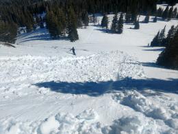
Over the past week there were natural and human triggered wet slab avalanches during warm, sunny days (photos page), including one that partially buried a rider (details) and one that surprised a couple skiers (details). Today similar avalanches are possible if above freezing temperatures and sunshine create a wet snowpack. Avalanche danger is LOW this morning and will rise to MODERATE this afternoon.
If you get out and have any avalanche or snowpack observations to share, contact us via our website, email (mtavalanche@gmail.com), phone (406-587-6984), or Instagram (#gnfacobs).
Upcoming Avalanche Education and Events
Spring is here and wet snow avalanches are becoming a daily concern. Anticipate decreasing stability while forming a travel plan. This article from Backcountry Magazine highlights some things look for that indicate when it is time to turn around.