Good morning. This is Doug Chabot with the Gallatin National Forest Avalanche Forecast issued on Thursday, March 21st at 6:30 a.m. Today's forecast is sponsored by Yellowstone Arctic Yamaha in partnership with the Friends of the Avalanche Center. This forecast does not apply to operating ski areas.
If you liked yesterday, you’ll like today: sunny skies, mountain temperatures in the 50’s and winds out of the east to southeast at 10-20 mph. This morning mountain temperatures are a few degrees below freezing except in the Bridger Range and Hyalite where an inversion has ridgetop temperatures in the low to mid 30’s. Tomorrow looks to be sunny, but snow and rain are expected this weekend.

All Regions
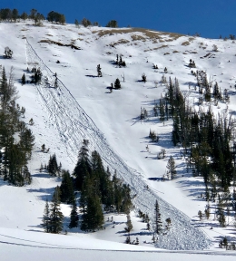
Conditions are changing rapidly and the snowpack is starting to fall apart. Yesterday there were many wet avalanches reported. Eric was in Beehive Basin and saw multiple wet loose slides and (photo) and got a good look at some wet slabs from the highway (photo). Skiers north of Cooke City saw similar conditions (photo). Cornices are weakening and sagging and are effective triggers to both wet and dry avalanches (photo, photo).
Above freezing temperatures and intense sunshine has wet the snowpack. On slopes where the snow is shallow and weak the melt-water will quickly create instability. Most mountain ranges froze last night, and even in the Bridger Range and Hyalite which had temperatures in the 30s, the snow surface will be frozen. After a few hours of morning sun the crust will melt and avalanche activity will increase. Cornices may break, wet point release slides will become numerous, and a few deep wet slabs will avalanche. Most of this action will occur on southerly facing slopes where solar input is greatest. If you start crashing to the ground in wet snow you know you overstayed your welcome and need to hurry home.
During Eric’s tour in Beehive Basin he had concerns regarding wet and dry snow. He backed off his plan to ski a high elevation north facing slope when he saw large cornices and obvious wind-loading from the ridgeline (video). In Bacon Rind on Tuesday I found southerly facing slopes quickly deteriorating from the warm temperatures and got easy fractures in my stability tests (video). Throughout the forecast area, snowpack structure and stability is changing quickly for the worse during the warm daylight hours. For today, the avalanche danger will start LOW, but become CONSIDERABLE by midday on slopes that get wet.
If you get out and have any avalanche or snowpack observations to share, contact us via our website, email (mtavalanche@gmail.com), phone (406-587-6984), or Instagram (#gnfacobs).
Spring is here and wet snow avalanches are becoming a daily concern. Anticipate decreasing stability while forming a travel plan. This article from Backcountry Magazine highlights some things look for that indicate when it is time to turn around.