All Avalanche Incidents for Advisory Year 2020-21
L-N-R2-D1-I
Elevation: 9,000
Coordinates: 45.4483, -110.9370
Caught: 0 ; Buried: 0
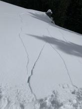
From notes: "There was about 6" of new snow in Flanders. It snowed on and off all morning and kicked in again around noon. There was no wind. We climbed Killer Pillar (E. facing, ~8600'). In about a 45 minute span we had 5-6 large sluffs barrel over the top of the climb and run a few hundred feet down the gully...a long ways... It was running so fast and far I had to stop and dig a quick pit to see why. It was near-surface faceting under the snow... LS-N-R2-D,... by the time they all ran I imagine a lot of the bowl above had released. I was super psyched that we both had our lighweight shovels and probes and were beeping. You just never know!"
More Avalanche Details


SS-N-R2-D1-I
Elevation: 9,000
Aspect: W
Coordinates: 45.3407, -111.3910
Caught: 0 ; Buried: 0
From obs: "Sometime mid-day the steep rocky terrain above the going home couloir as well as the start zones in Tyler’s avalanched, just new snow, SS-N-D1R2-I. Just guessing about the trigger but didn’t see tracks going in, although there were certainly lots of people around." Photo: Sam H.
More Avalanche Details


Coordinates: 44.9592, -111.3130
Caught: 0 ; Buried: 0
Riders in Taylor Fork and Cabin Creek reported cracking and whumphing in the new snow, and another group reported "some big avalanches out near the 'Beaver Slide'... north aspect and steep terrain. Pretty much all the snow to the ground."
More Avalanche Details

SS-AS-R3-D2-O
Aspect: NE
Coordinates: 45.2892, -111.2960
Caught: 0 ; Buried: 0
The NE facing slopes of Dudley Creek are struggling to hold the new snow. I easily triggered the 6-8" of new and windblown snow but it is also stepping down to the facets buried deeper.
More Avalanche Details

Coordinates: 45.0432, -110.9620
Caught: 0 ; Buried: 0
From obs: "While skiing a loaded east aspect in the Southern Gallatin, my partner got a large collapse as he started to break trail back to our skin track, cracks shot 20ish feet uphill."
More Avalanche Details

SS-AKu-R2-D2-O
Elevation: 8,800
Aspect: N
Coordinates: 44.9695, -111.2920
Caught: 0 ; Buried: 0
A snowmobiler triggered an avalanche while side-hilling. No one caught or injured. The debris was estimated to be 8' deep.
More Avalanche Details

L-N-R1-D1-I
Elevation: 8,000
Coordinates: 45.8822, -110.9520
Caught: 0 ; Buried: 0
Multiple small dry looses all across the throne. Sliding on a thin sun crust with overlying near surface facets buried 15-25 cms down. None stepped down to deeper layers.
More Avalanche Details


AMu
Aspect: S
Coordinates: 45.0202, -109.9380
Caught: 1 ; Buried: 0
CCMS called and said a rider triggered a slide about 1/4 mile north of Huckelberry Lake on a south facing slope. It trashed a rental sled. The rider was at the crown when it broke and was above most of the debris. He was only buried to his knees and was uninjured. No details on size or depth of slide. A close call.
More Avalanche Details

SS-N-R2-D2-O
Aspect: E
Coordinates: 44.9560, -111.1320
Caught: 0 ; Buried: 0
Skiers reported a natural avalanche on Ernie Miller Ridge. Occurred with minimal new snow on a layer of weak depth hoar.
More Avalanche Details

SS-AMu-R2-D2-O
Elevation: 9,800
Aspect: S
Coordinates: 45.0722, -109.9280
Caught: 0 ; Buried: 0
Snowmobilers triggered two avalanches on 1/22/2021. A group of 11 were climbing on the southside of Sheep Mountain. The slides were triggered by two separate riders.
More Avalanche Details


SS-N-R2-D2-O
Elevation: 9,000
Aspect: SE
Coordinates: 44.7292, -111.3230
Caught: 0 ; Buried: 0
On 1/23/21 we saw a couple recent natural avalanche crown on Bald Peak near Lionhead Ridge. Estimated 2-3 days old.
More Avalanche Details

SS-N-R1-D1.5
Coordinates: 45.4164, -110.9700
Caught: 0 ; Buried: 0
From skier in Hyalite on 1/23/21: "I observed a couple older (1-2 week) naturals on E/ESE aspects in the Divide basin, and newer (1-3 days) naturals on the NE side of Divide and an east aspect at the head of the Maid of the Mist basin."
More Avalanche Details


SS-AMu-R2-D2-O
Aspect: E
Coordinates: 44.9041, -111.1850
Caught: 0 ; Buried: 0
More Avalanche Details


Coordinates: 44.9855, -109.9410
Caught: 0 ; Buried: 0
From Obs: "On a W facing slope in dense trees just east of the Republic Creek skin track, 8200" - 9200". Snow was not wind loaded at all. There was a buried weak layer about a foot below the new snow, but the new snow had not formed a slab so stability seemed good. There was one incident of a collapse crossing a small gully at about 40deg, a crack formed but did not slide probably due to no wind loading."
More Avalanche Details
SS-AMu
Coordinates: 45.0344, -109.9840
Caught: 0 ; Buried: 0
A group of seven riders in Sheep Creek triggered one avalanche and observed two more. The slide failed 1' deep likely on surface hoar. No one was buried or injured.
More Avalanche Details
SS-AS-R2-O
Elevation: 9,500
Aspect: S
Coordinates: 45.0202, -109.9380
Caught: 0 ; Buried: 0
A skier near Goose Lake observed two human triggered avalanches, one looked to be skier triggered and one looked to be snowmobile triggered. Solar aspects around 9500'. The skier dug at pit and found at least one failed on buried surface hoar.
More Avalanche Details

SS-N-R1-D1
Coordinates: 45.4444, -111.0040
Caught: 0 ; Buried: 0
A skier near Mt Blackmore obsersed two loose snow avalanches on the east face of Blackmore and a small slab avalanche on the north face. Continued active wind-loading.
More Avalanche Details


SS-AM-R1-D1.5
Aspect: N
Coordinates: 45.1719, -111.3800
Caught: 0 ; Buried: 0
Snowmobile triggered avalanche on a north-facing slope in Second Yellowmule. Likely occurred on 1/18.
More Avalanche Details


Coordinates: 45.0254, -110.0310
Caught: 0 ; Buried: 0
From obs: "Extremely touchy snowpack in the pebble creek drainage. Nearly constant collapsing and cracks were shooting very long distances. Snowpack was definitely sending a clear message!"
More Avalanche Details
SS-ASc-R2-D1-O
Aspect: SE
Coordinates: 45.0202, -109.9380
Caught: 0 ; Buried: 0
Skier intentionally cut a small pocket on s SE slope. It broke 3-4" deep on recently buried surface hoar.
More Avalanche Details

Elevation: 10,000
Aspect: SE
Coordinates: 45.0714, -109.9440
Caught: 0 ; Buried: 0
From obs: "While skinning up the south shoulder of Scotch Bonnet, about half way (~10,000 ft.) shooting cracks occurred on convexities and were accompanied by whumpfing. While traversing a slope a crack shot perpendicular to the slope at a convexity about 60 ft. up and the whole slope collapsed. After this we immediately turned around taking the most conservative path. These conditions were not present lower down the slope and a snow pit showed no propagation with only a Q3 fracture on the recent layer of surface hoar. It seemed that the higher elevation and more southern aspect decreased the stability of the recent surface hoar layer. The surface hoar layer was not reactive on more westerly slopes."
More Avalanche Details

HS-N-R2-D2-O
Elevation: 9,800
Aspect: E
Coordinates: 45.3934, -110.9690
Caught: 0 ; Buried: 0
More Avalanche Details

SS-N-R2-D2
Elevation: 9,000
Coordinates: 45.0607, -111.2720
Caught: 0 ; Buried: 0
There were 10 natural avalanches from Wednesday's snow and wind and event in the Taylor Fork. All were small to medium size. Many broke at the new snow interface, some broke deeper on weak facets near the ground.
More Avalanche Details


SS-N
Aspect: E
Coordinates: 45.0432, -110.9620
Caught: 0 ; Buried: 0
From an email obervation:
...widespread avalanche activity.
...central Gallatin Range, a mid elevation easterly aspect.
More Avalanche Details

SS-N
Coordinates: 45.0202, -109.9380
Caught: 0 ; Buried: 0
... 3 photos are from around Cooke City, all viewed from the road today (photos 1 and 3 are westerly aspects). Photo 2 is a northerly aspect. All mid elevations.
More Avalanche Details


SS-N-R2-D2
Elevation: 10,000
Aspect: E
Coordinates: 44.9952, -109.9080
Caught: 0 ; Buried: 0
Natural avalanche observed on Climax path in Hayden creek on 1/13/21.
More Avalanche Details

Coordinates: 45.0432, -110.9620
Caught: 0 ; Buried: 0
"Cracking, collapsing, wumphs in the Southern Gallatin. ECTP 22. West facing, 8200’ non windloaded, 80cm of snow. Broke 50cm deep on depth hoar. Barely a cohesive slab on top but still enough to cause unstable conditions."
More Avalanche Details

SS-N
Aspect: W
Coordinates: 45.7976, -110.9380
Caught: 0 ; Buried: 0
From the Bridger Bowl Ski Patrol:
Natural avalanche activity was seen on the Cornice below the Y on Bostwick Drainage and behind the Poma lift in Truman Gulch.
More Avalanche Details

Coordinates: 45.2844, -111.3280
Caught: 0 ; Buried: 0
"Upside-down snowpack, with a ~1ft strong layer on top of a few inches of weak snow. Significant shooting cracks and whoomphing in areas with deep snow. There was comparatively little snow in the trees -- not enough to cause avalanche concerns. We stayed off high-angle slopes, because of the clear signs of avalanche danger, and the very warm temps."
More Avalanche Details
SS-N-R2-D1.5-O
Aspect: E
Coordinates: 44.7145, -111.3180
Caught: 0 ; Buried: 0
This natural avalanche likely releaed fron the new snow (about .5" SWE) and strong winds during the day.
More Avalanche Details

SS-R2-D2-O
Elevation: 8,600
Aspect: E
Coordinates: 45.7943, -110.9360
Caught: 0 ; Buried: 0
Routine avalanche mitigation within the boundaries of Bridger Bowl sympathetically caused half of the Football Field on Saddle Peak to avalanche immediately south of the boundary. "Debris ran over the cliffs pulling out spindrift cones that were up to 5 ft deep."
*Note: Ski Patrols do not perform any avalanche mitigation outside ski area boundaries.
More Avalanche Details

Coordinates: 45.4472, -110.9620
Caught: 0 ; Buried: 0
From obs: "While ski touring in the Hyalite Creek Drainage today, my ski partner and I both, at separate times of the day, remote triggered sudden collapses. Each time, we felt the snow collapse underneath our feet, and then heard and felt a deep "whumph". The noise came from the North of us both times, where the slope was slightly steeper (still below about 28 degrees-- not colored with "slope angle shading" layer on caltopo.)."
More Avalanche Details
Coordinates: 44.9609, -111.1000
Caught: 0 ; Buried: 0
From email: "...I found a small piece of this mostly low angle slope to have avalanched, probably from a day or two ago, a handful of older tracks were near it. I measure most of this slope around 26-28 degrees... This is on the farthest south part of the top meadow. An epic amount of whumphs up there, I stopped counting after I got to 10 on my second switch back. Our best one knocked snow out of a tree 100’ away. It feels like remote triggering is a very real possibility. Skies were more overcast than expected. While it never went blue, the sun poked out a little in the afternoon. Cold temps, 0F in the AM, warmed to 24F in the PM. 5-6mm surface hoar everywhere,..."
More Avalanche Details


Coordinates: 44.9560, -111.1320
Caught: 0 ; Buried: 0
From obs: "We were heading for Ernie Miller Ridge, but got deterred by our group hearing MORE COLLAPSES AND SETTLEMENTS THAN I'VE EVER HEARD IN A SINGLE TRIP, in over 23 years of backcountry skiing. Some in the open, some in the woods. Some small, some HUGE and FAR running. Some heard by the person in front, some by the 4th in our party, some where we were following an old skin track, some where we were in fresh snow. As a group we probably heard 25 over the course of the day. We didn't dig any formal pits, as the snow was telling us all we needed to know. Stay safe out there. Thanks"
More Avalanche Details
SS-AMu-R2-D2-O
Elevation: 9,000
Coordinates: 44.7145, -111.3180
Caught: 0 ; Buried: 0
Many snowmobile triggered avalanches were observed after new snow overloaded a very weak snowpack.
More Avalanche Details


SS-N-R1-D1-O
Elevation: 10,000
Aspect: NE
Coordinates: 44.9739, -109.9240
Caught: 0 ; Buried: 0
From email: "I was skiing in Hayden Creek yesterday 20210109 with two others. We found widespread poor structure across the E face of the sub with some failure upon isolation down 65-80cm on 2-3mm faceted crystals HS varied from 110-230cm. We also saw one small R1D1 pocket that pulled out seemingly at the same depth as the aforementioned faceted crystals In slightly steeper and rockier terrain. No photo. The avalanche was on a ENE aspect on Hayden Peak."
More Avalanche Details
SS-ASc-R3-D2-O
Elevation: 8,700
Aspect: NW
Coordinates: 45.0839, -109.9690
Caught: 0 ; Buried: 0
From obs: "1/9/21 350pm: 333 deg NNW, broke on ski cut lookers right approx 60 ft across, 200 ft or so total distance to toe of debris. Broke 2.5/3 ft deep on a wind loaded pocket, slid on a firm surface with facets on top."
More Avalanche Details


Elevation: 8,500
Aspect: N
Coordinates: 45.0003, -109.9540
Caught: 0 ; Buried: 0
This activity was reported by an observer in Cooke City on 1/9/20. They watched the group trigger this slide while they skinned up, then they descended from a little bit higher.
More Avalanche Details

SS-N-O
Elevation: 9,000
Coordinates: 45.1719, -111.3800
Caught: 0 ; Buried: 0
A rider submitted photos of cracks he triggered as well as a suspected natural avalanche and wide shooting cracks, all observed on 1/9/21.
More Avalanche Details


Coordinates: 45.4444, -111.0040
Caught: 0 ; Buried: 0
From email: "Got up to Blackmore way. I didn’t like the skin track heading up to N ridge but my partner was a little ahead and should of reeled him back... because the main skinner right now is exposed to much of face. So when caught up we angle lookers right a tidge to gain ridge. Just before the ridge was the disturbing collapse."
More Avalanche Details
SS-AM-R2-D2
Coordinates: 44.5476, -111.5250
Caught: 0 ; Buried: 0
From obs: "...Two natural slab avalanches on north aspect of Reas Peak, one from recent storm and one from previous storm. Photo is from a snowmobile triggered avalanche from 1/9/21, you can see the party and one of the members riding the adjacent slope."
More Avalanche Details

SS-N-R2-D1.5-O
Elevation: 9,000
Aspect: N
Coordinates: 45.0923, -109.9510
Caught: 0 ; Buried: 0
From email: "We suspect this happened fresh today, we wonder if those animal tracks coming in from the left triggered it. North facing, 2 ft crown, (I’d guess), about 9k feet, facing Goose Creek. So our friends (while ski cutting) triggered a very similar slide on this same aspect/elevation mid afternoon today, about 1/4 mile farther west along this ridge, looked to be same depth."
More Avalanche Details

Coordinates: 44.8381, -111.3430
Caught: 0 ; Buried: 0
From obs: "Skied Lionhead above Hebgen Lake today. Had cracking and collapsing almost constantly on the ascent and along the ridge line. Stuck to low angle terrain and did not trigger anything that moved. No natural avalanche activity."
More Avalanche Details
Coordinates: 45.2952, -111.4100
Caught: 0 ; Buried: 0
I skied in the Northern Madison range today. We had 3 big whumps/collapses on a NE aspect between 7600 and 8000 feet. Kept the slope angle low so nothing slid. The snowpack was about 80 to 90 cm deep outside of tree cover. The skiing was good quality powder skiing.
We dug a pit on that slope and got an ECTP 23. Not super clean shear quality as it was on the facet layer on the ground.
More Avalanche Details
HS-ASu-R4-D2.5-O
Elevation: 9,800
Aspect: E
Coordinates: 45.4359, -110.9440
Caught: 0 ; Buried: 0
From obs: "We dug a pit and found a really weak snowpack! Regardless of the poor stability result, we proceeded to ski an East facing bowl south of Flanders Mountain knowing that the slope angle was low and only flirted with 30 degrees in some parts of the bowl. We could have chosen to ski the trees further to our left, but after evaluating the consequence associated with skiing the bowl, we decided that the center of the bowl did not pose too big a risk given we skied one at a time. My partner skied first, he skied practically all the way back to the skin track when the slope failed and the entire bowl released. He was pretty well out of the way of danger by the time the bowl began to move. From our perspective, the trigger happened at the bottom of the slope.... The bowl was not the only slope that slid, the avalanche propagated around the ridge and released a slide on the more south-easterly facing aspect just south of the bowl. We tail-tucked and went home glad no one was caught or hurt."
GNFAC forecasters visited the site on 1/11/21. We measured the maximum slope angle in the start zone at 35 degrees with an average slope angle of 33 degrees. The debris in each path was up to 2-3 meters deep. The avalanche broke on a layer of weak faceted snow 70 cm above the ground, and propagated almost 1000 feet wide. The crown was 2-3 feet deep.
More Avalanche Details


Coordinates: 45.8427, -110.9370
Caught: 0 ; Buried: 0
From obs: "the whumpf I had heard previously remotely triggered a series of 7-8 large cracks that ranged from 30-100 feet wide. ... As I carefully descended the meadow, I saw many more cracks throughout the slope from the same remote trigger event. Additionally, I triggered two more significant whumpfs with shooting cracks 10-40 feet wide. We determined our remote trigger was at least 300 feet away from where the snow collapsed and cracked"
More Avalanche Details

Elevation: 9,350
Aspect: SE
Coordinates: 45.0270, -110.0030
Caught: 1 ; Buried: 0
From observation (1/8/21): "Skier triggered slide from someone outside our group lower in Silver Creek 9350’ S facing 18-24” deep 60-70’ wide. Ran 500’ skier was able to regain skis and off slab 100’ below initiation."
More Avalanche Details


Elevation: 9,000
Aspect: E
Coordinates: 45.1274, -111.2660
Caught: 0 ; Buried: 0
From obs: "Shooting cracks and collapsing on the entire ascent to the Cinnamon Creek Lookout. Remotely triggered a R2-D2.5 on descent. 2-3 foot crown. Slide path was on an East facing slope at 9000ft. Failed on the same persistent weak layer being seen across most regions of the forecast zone."
More Avalanche Details

Coordinates: 45.2938, -111.3210
Caught: 0 ; Buried: 0
From obs (1/8/21): "Loud whoomphs and collapses while skinning uphill, from the car until we turned around about 400ft below the summit. Snowpack felt extremely responsive and we carefully avoided all avalanche terrain."
More Avalanche Details
SS-ASu-R2-D2.5-O
Elevation: 9,700
Aspect: E
Coordinates: 45.0046, -109.9580
Caught: 3 ; Buried: 1
FULL AVALANCHE REPORT: https://www.mtavalanche.com/accident/21/01/11
On January 8, 2021 a group of six skiers triggered an avalanche on The Fin on Republic Mountain outside of Cooke City. They were skinning up the slope when they felt the slope collapse and watched cracks propagate 250’ upslope. Three were caught and partially buried. Skier 1 deployed his airbag, was partially buried and able to get himself free. He freed himself from the debris and began a beacon search which led him to see skier 2 who was buried head down with his airway obstructed. He was uncovered by skier 1, not breathing and unconscious. He sustained injuries, but later made it out under his own power. Skier 3 was partially buried higher in the path, sustained serious injuries to his ribs and lungs and was evacuated by helicopter. The avalanche broke 1.5’- 2’ deep, 200’ wide and ran 700’ vertical. The average slope angle was 37 degrees. Slope angle at the crown was 33 degrees on an east aspect at 9,700’ elevation. The avalanche is classified SS-ASu-R2-D2.5-O.
More Avalanche Details


SS-N-R1-D1
Elevation: 9,700
Aspect: E
Coordinates: 45.0202, -109.9380
Caught: 0 ; Buried: 0
Natural avalanche NW of Cooke City on an E, SE aspect around 9,700'.
Photo: B. Fredlund
More Avalanche Details

HS-AMu-R4-D2-O
Elevation: 9,350
Aspect: NE
Coordinates: 45.1719, -111.3800
Caught: 0 ; Buried: 0
We saw this relatively very large, full width avalanches that was triggered on January 7, 2021. It broke on weak, sugary snow below hard wind drifted snow and recent new snow.
More Avalanche Details


HS-AMu-R3-D2-O
Elevation: 9,300
Aspect: NE
Coordinates: 45.1719, -111.3800
Caught: 0 ; Buried: 0
We saw two large snowmobile triggered avalanches (and one very large, in separate record) that occurred on January 7, 2021. They broke on weak, sugary snow below hard wind drifted snow and recent new snow.
More Avalanche Details


HS-R2-D2.5
Coordinates: 45.9091, -110.9770
Caught: 0 ; Buried: 0
Large natural avalanche north of Hardscrabble Peak near Fairy Lake. Likely broke during snowfall/wind on Thursday, Jan 7th.
More Avalanche Details


SS-N-R2-D2-O
Elevation: 9,500
Coordinates: 45.1719, -111.3800
Caught: 0 ; Buried: 0
We rode on Buck Ridge on January 8th 2021. We saw six recent natural avalanches and three snowmobile triggered slides. Based on 3-4" of snow that fell yesterday morning covering the debris, we estimate the several natural slides ran 24-48 hours ago. They likely broke on January 6 after the area got 8" of snow on the 5th.
More Avalanche Details


SS-N
Coordinates: 45.0202, -109.9380
Caught: 0 ; Buried: 0
"We observed at least a half a dozen recent/ fresh slab avalanches north of Cooke City today. These slab avalanches were found: on all aspects, near ridgelines, and also on many aprons. We also had one large collapse on an alpine E aspect, from the third skier climbing up the skin track."
More Avalanche Details


Coordinates: 45.0932, -110.5690
Caught: 0 ; Buried: 0
On a wind loaded, rocky slope off the summit of Bald Mountain we triggered a remote slide about a 100 across from us while skiing. Conditions elsewhere in the area were decent, but the exposed, wind loaded slopes showed activity with whoomping and cracks, and the one avalanche. None where hurt or caught. Conditions were as advised in the avalanche report.
More Avalanche Details

Coordinates: 44.7145, -111.3180
Caught: 0 ; Buried: 0
From IG:
"Skinning around in the Lionhead range today on under 20° slopes we heard whumphing and saw shooting cracks several times over 4 miles."
More Avalanche Details
Coordinates: 45.2615, -111.3150
Caught: 0 ; Buried: 0
"Shallow snowpack 24-36” from 6800-9200 ft S and E aspect. Facets on the ground 6-12” deep. Widespread collapsing and cracks all the way on low angle terrain to the top. Big shooting crack across the south facing path from the skin track so expected the east bowl to remotely trigger and it did from 25m away on the ridge. R3D2 slide. Confirms all previous regional reports and the concerns of the day, typical in this specific area early season. Obsessive terrain management is the only way just now."
More Avalanche Details

SS-AS-R1-D1.5
Elevation: 8,000
Aspect: S
Coordinates: 45.8322, -110.9280
Caught: 0 ; Buried: 0
I was skiing down the apron at Bridger and noticed this slide on Bradley's that appeared to be skier triggered. Picture's were taken at about 2pm. I don't believe this activity was there when I came down the apron earlier in the day around 11:45. I talked to patrol about it and they had not heard anything about it at the time. It appeared both tracks going in, came out. Thanks for all the work you guys do!
More Avalanche Details

Aspect: W
Coordinates: 45.0432, -110.9620
Caught: 0 ; Buried: 0
"...the snowpack was talkative today. Tons of energetic rolling collapses that shook snow out of the trees 50 feet away, and shot powder up around aspens in a Colorado-esque way. Shooting cracks on low-angle test slopes, and isolated small natural slides on steeper, W-facing terrain."
More Avalanche Details

SS-NCc
Aspect: N
Coordinates: 45.0017, -109.9550
Caught: 0 ; Buried: 0
"We headed up Republic with the intention of skiing one of the north couloirs but decided against it once we reached the top. We still managed to drop a fairly large cornice down one of them, triggering a soft slab that ran a ways into the apron below but didn’t step down to anything deeper. While side hilling on the solar side of the East ridge on the way back down towards our skin track we felt a very substantial wumph."
More Avalanche Details
N-R2-D2
Coordinates: 45.3447, -111.3860
Caught: 0 ; Buried: 0
From obs on 1/8/21: "Observed numerous natural avalanches that had slid before this most recent snow storm. All on n or ne aspects going on the basal facets. Up to D2ish"
More Avalanche Details

SS-R3-D1.5-O
Elevation: 9,300
Coordinates: 44.9528, -111.3170
Caught: 0 ; Buried: 0
There were many avalanches on the Upper Sage Creek Ridgeline. These were on east through northeast facing slopes at 9300' elevation. The avalanches failed on the weak facets near the ground. They were one or two days old. Unknown triggers, they were likely both natural and snowmobile triggered.
More Avalanche Details


SS-N-R1-D1
Coordinates: 44.9609, -111.1000
Caught: 0 ; Buried: 0
Four small natural avalanches (<20 ft wide) broken on small slopes above the Gallatin River during the avalanche warning on January 5th, 2021.
More Avalanche Details

SS-N
Elevation: 8,000
Coordinates: 45.1719, -111.3800
Caught: 0 ; Buried: 0
More Avalanche Details

Caught: 0 ; Buried: 0
"The BC is showing signs of instability all around us-large slides were observed in Lone Lake (basal crust), northerly exposure, out on Cedar in Dirty Bowl, northerly exposure,which slid to ground, and in Beehive Basin."
More Avalanche Details

Caught: 0 ; Buried: 0
From an IG message:
A person remotely triggered a large avalanche 200' wide and 800' slope distance on 1/5/21. The crown was 2' thick and broke on depth hoar which is on most slopes above 8,000'. No one was caught.
More Avalanche Details
Coordinates: 44.8899, -110.3330
Caught: 0 ; Buried: 0
In Lamar Valley:
Today in Chrystal Creek my group of 4 skiers triggered 3 cornices. 2 remotely triggered and one small one while skiing off of it. The slope below was not steep enough to slide far. ~75cm of snow where we dug our pit on a North slope at 26 degrees. One slab ~23cm off the ground didn’t cause any real problems. Another hard slab ~35cm-42cm sitting on facets broke at ECTP7, CTPV. Had more whumphs than we could count and cracks that shot 30+ meters. Snow depth varied greatly, some wind loading.
More Avalanche Details

SS-N
Coordinates: 45.0303, -109.9980
Caught: 0 ; Buried: 0
New snow: about 6" of fresh in town- from last night.
More Avalanche Details

L-N
Coordinates: 45.0566, -109.9510
Caught: 0 ; Buried: 0
Cooke got 6" (.6" SWE) last night.
1. Natural, unwitnessed avalanche on Scotch Bonnet, S aspect.
2. Natural avalanche on SE wind loaded slope in Sheep Basin - Wolverine Peak.
More Avalanche Details

SS-ASr-O
Elevation: 9,500
Aspect: S
Coordinates: 45.0408, -109.9400
Caught: 0 ; Buried: 0
Remote triggered a soft slab with a ski cut. Cut across top of slope and the slide initiated ten yards below. slide was approximately 25 feet at the crown and ran the whole length/ width of the gulley. Couldn’t see past the choke of the gulley . Thicker at the crown where snow was wind drifted 16 in~. Dug a quick pit after. HS 80 cm. Slab on top of crust and facets. No one was caught and we skinned back up and skied out our original skin track.
More Avalanche Details


Coordinates: 45.5243, -110.9560
Caught: 0 ; Buried: 0
A skier got a collapse and crack in Lick Creek. The collapse has sizeable displacement which is indicative of a very thick and unstable weak layer.
More Avalanche Details

HS-N
Elevation: 9,000
Aspect: E
Coordinates: 45.7869, -110.9350
Caught: 0 ; Buried: 0
Natural avalanche that ran during or prior to storm morning of 1/5/21. An Avalanche Warning was issued that morning.
More Avalanche Details

SS-N
Elevation: 9,000
Aspect: E
Coordinates: 44.7145, -111.3180
Caught: 0 ; Buried: 0
A Custer Gallatin NF Snow Ranger saw a crown line under the rock band on Lionhead Ridge.
On Jan 6, GNFAC forecaster's saw debris below the ridgeline in two paths, but didn't have enough visibility to get more info about the slides.
More Avalanche Details
SS-AKu-R2-D1
Elevation: 7,200
Coordinates: 45.0566, -110.6180
Caught: 0 ; Buried: 0
"This morning we had volunteers who were grooming the bear creek cross-country ski trails above Jardine NE of Gardiner in the southern Absarokas outside the forecast area. They witnessed a couple of roadcut slopes above the trail that triggered as they passed by or had recently occurred. Slides were roughly 18" deep and occurred at 7,200 feet elevation."
More Avalanche Details


HS-N-R3-D2.5-O
Elevation: 9,100
Aspect: NE
Coordinates: 45.7943, -110.9360
Caught: 0 ; Buried: 0
The crown line of this natural avalanche was seen near the summit of Saddle Peak. It likely broke in the morning of Jan 5 during the snowstorm that dropped .8" SWE and prompted an Avalanche Warning.
More Avalanche Details

SS-N-R2-D2
Coordinates: 45.2981, -111.5240
Caught: 0 ; Buried: 0
Three natural avalanches seen on Fan Mountain from Big Sky Ski Resort
More Avalanche Details

C-NC-R2-D2
Elevation: 9,600
Aspect: E
Coordinates: 45.3934, -110.9690
Caught: 0 ; Buried: 0
A backcountry skier wrote, "...observed a fairly large, cornice-triggered avalanche on an east aspect at 9600’ that looked to be several hours old. The crown was 40-100 cm deep, and it looked like it failed about 20 cm into the facets that make up the lower half of the snowpack in this region."
More Avalanche Details


Elevation: 8,500
Aspect: E
Coordinates: 44.9609, -111.1000
Caught: 0 ; Buried: 0
Toured up Bacon Rind today. As expected we experienced dozens of massive collapses, shooting cracks, etc and were able to crack test slopes easily. Pretty fun really. Above 8k the slab became more supportable and collapses became less frequent, but traveled further. Needless to say we avoided all terrain over 30 degrees. It was snowing hard (S5) with moderate South winds when we left to drive home (1700), but it was clear by the time we got to Specimen Creek.
More Avalanche Details
Aspect: E
Coordinates: 44.8381, -111.3430
Caught: 0 ; Buried: 0
Observation 1:
Sun 1/3: Skied both north and east facing terrain on the west side of Hebgen today. The few inches of new snow that has fallen recently seemed a bit denser than what was already on the ground. Made for an EXTREMELY touchy day. Widespread whumpfing and collapsing everywhere we went. We kept our slope angles low. On one slope we had a large collapse when the first skier started which created many longitudinal cracks across the entire width and length of the slope. We measured the slope at 27 degrees - I am confident a steeper slope in this area would have easily released.
Observation 2:
Summary of observations from Sat 1/2 and Sun 1/3: -No avalanches observed -Lots of whumphing and shooting cracks on N through SE aspects between 6600' and 8900' -3" of new snow at 8900' within 24 hour period from Saturday to Sunday; snowed S1 for a few hours Sunday morning but stopped by 1 p.m. and skies went from obscured at 9:00 a.m. to broken at 3:00 p.m. -Imperceptibly calm winds on Sunday below ridgetop at 8900' and trees holding snow at all elevations; ridge at 8900' had light Westerly winds gusting at moderate; we observed blowing and drifting snow at ridgetop being deposited on NE through E slopes. Snowpit Data from E aspect at 8200' (26 degree slope) on Saturday 1/2 at 1:00 pm: HS 75cm Weakest layer found at 50 cm down; weak layer is the interface between F-hardness basal facets (2-3mm) and 4-F, smaller facets above them Test results on this layer were ECTPV, ECTP13, and PST 25/100 (end)
More Avalanche Details
Aspect: N
Coordinates: 45.0709, -109.9580
Caught: 0 ; Buried: 0
Found cracking/propagation on wind-loaded roll overs, 8-16’’+ fractures, while touring today. Was enough to keep us out of the gullies. North facing bench glades across from Scotch Bonnet, just below Lulu pass above the old buildings.
More Avalanche Details
SS-AFu
Elevation: 9,200
Aspect: W
Coordinates: 45.4472, -110.9620
Caught: 0 ; Buried: 0
A first person account: "Human triggered avalanche at (estimate) 1:30pm from upper 'Avalanche Gulch' by one party descending from 'Dribbles'. Climber on second moderate pitch of 'Avalanche Gulch' swept but saved by screw placement from going over pitch 1 of Avalanche Gulch. No injuries, no burials, and both parties reconvened at base of Avalanche Gulch to assess the event. All parties descended at 3pm."
More info:
More Avalanche Details
C-NC-R1-D1.5
Elevation: 10,000
Aspect: N
Coordinates: 45.4444, -111.0040
Caught: 0 ; Buried: 0
From obs: "Skied Mt Blackmore this morning. Very windy up in the basin, but calm along the ridgeline. Lots of signs of wind-loading and drifting on most slopes. I felt/heard 3 collapses while ascending the trees up to the east ridge. Saw a debris pile on the N face, likely from a cornice fall in the last 24hrs."
More Avalanche Details

Coordinates: 45.4381, -110.9410
Caught: 0 ; Buried: 0
From obs: "This morning I was ascending Flanders Peak via the southeast trees. At approximately 1:30PM, on our second lap of the south-southeast bowl of Flanders Peak, I was skinning behind my friend who was putting in a new ascent track when we both heard a large "whump" and a 15 foot crack shot out from under his skis. I also witnessed him drop several inches from the large collapse in the snow. We were on a very low angle slope (less than 25 degrees) at approximately 9700 feet, in wide open trees right at the edge of tree-line and the alpine. We noticed no other signs of instability in the bowl we skied, or on the wind-loaded ridge."
More Avalanche Details
SS-ASu-R2-D1.5-I
Elevation: 10,500
Aspect: N
Coordinates: 44.9756, -110.0310
Caught: 0 ; Buried: 0
Skiers triggered a wind slab while ascending the north couloir on Abiathar Peak on 1/2/21. On their descent they triggered another similar sized slab. They were not caught or injured, and felt lucky to "dodge a bullet".
From email: "We approached Abiathar north cirque intending to climb and ski the north couloir. Two extended column tests were performed and it was determined that the main threat was new snow on shallow facets... At approx 10,500' the first member of our party released the first slab, so we pulled the plug and began to prepare for descent. Upon descent, I dropped first and faded left to eddy out behind a rock outcrop and released the second slab, which broke just upslope of me. I was able to edge into the bed surface and the slab ran past without incident."
More Avalanche Details


Elevation: 9,000
Aspect: E
Coordinates: 44.8381, -111.3430
Caught: 0 ; Buried: 0
From obs: "Skied the west side of Hebgen Lake today... Experienced widespread whumpfing and shooting cracks on east facing terrain from Lake to over 9000 ft. Dug a pit at 8300 ft. Very weak snow with little structure, but the midpack had a distinct density change with 4F hardness. Large facets close to being depth hoar (~3mm) developing at ground. ECTP17 at the top of this basal layer. My friend also did a PST in a nearby pit and got propagation at 20cm/120cm on the same layer."
More Avalanche Details
Coordinates: 45.0432, -110.9620
Caught: 0 ; Buried: 0
From obs: "Today in the southern gallatin we found widespread poor structure (surprise) with the bottom 30 cm of the snowpack consisting of FC and full on DH. Moderate winds were rapidly drifting the new snow, and anywhere with a new load/slightly stiffer slab was collapsing, with shooting cracks, remote triggers of shallow wind slabs, etc. Some of the collapses ran for over 30m. We were BTL, but I expect that at and above treeline wind slabs were touchy today, with remote triggers possible."
More Avalanche Details
SS-ASr-R2-D2-O
Elevation: 9,100
Aspect: SE
Coordinates: 45.0254, -110.0310
Caught: 0 ; Buried: 0
Skiers triggered a slide remotely, from low angle terrain, on a 9100’ SE aspect. It was a 1.5'-2' deep soft slab (4F+ to F hard) that broke on weak sugary facets.
From obs: "Did a test pit at same elevation 30’ away on S asp in thin area (HS70cm). ECTN6 down15 on new snow interface & ECTN 16 down 35 on the 4F+DF/RG : F, FC interface. We skinned around to the shoulder heard/felt a whumph (similar magnitude/duration/est. dist prop to other whumphs occurring in the last 2 days) and saw the avalanche. Trigger distance ~15’ from first person."
More Avalanche Details


Coordinates: 45.3273, -111.3810
Caught: 0 ; Buried: 0
From obs; "After the four of us skied, transitioned, and started skinning back up, the fourth member of our party (who was the last person skinning) heard a loud "whumpf" and saw a shooting crack propagate from our skin track to the right and left of us, approximately 60-80' wide. The slope was around 25 degrees."
A second party of skiers also got a large whumpf in Bear Basin.
More Avalanche Details

HS-AS-R2-D2.5-O
Elevation: 9,000
Aspect: NE
Coordinates: 45.7943, -110.9360
Caught: 0 ; Buried: 0
On January 1, 2021 at approximately 1530 a skier triggered an avalanche on Saddle Peak south of Bridger Bowl. He left from the ski area around 1445 and skin up the ridge out of bounds to the south. Shortly after, patrol witnessed the avalanche and then later saw the solo skier returning to the ski area after descending the bed surface of the avalanche. The skier reported the event to patrol when he returned. He stomped at the rollover below the summit, on the south end of the low angle ridge, and it broke 3 ft deep....ran down north central and the main face.
More Avalanche Details


SS-AMu-R2-D2-O
Elevation: 9,800
Aspect: SE
Coordinates: 45.0525, -109.9620
Caught: 0 ; Buried: 0; Killed: 0
A snowmobile triggered avalanche broke 1-2' deep on a layer of near surface facets sandwiched between two crusts.
More Avalanche Details


Coordinates: 44.9609, -111.1000
Caught: 0 ; Buried: 0
Skiers at Bacon Rind triggered 20+ "Monster Whumphs." They were quickly convinced to stay out of avalanche terrain by these red flags.
More Avalanche Details
Coordinates: 45.0607, -111.2720
Caught: 0 ; Buried: 0
Touring through low angle meadow we triggered collapses ("whumphs") numbering in the dozens. Some had associated cracking extending about 20' from the point of initiation.
More Avalanche Details

L-N-R1-D1
Coordinates: 45.4402, -110.9310
Caught: 0 ; Buried: 0
A skier in the Flanders drainage observed a small loose snow avalanche.
More Avalanche Details

SS-ASu-R1-D1-O
Elevation: 9,500
Aspect: E
Coordinates: 45.4446, -111.0000
Caught: 0 ; Buried: 0
From obs: "Skier Triggered a 1.5' slide to his right while making a turn near a cliff band. The slide did not intersect with the skier's path. We did a ECT before choosing our line and were not able to get the soft slab, or anything else to propagate, but clearly, the slab is ready to go as it slid on rocks. We both skied out without incident."
More Avalanche Details


SS-AMu-R2-D1.5-O
Elevation: 9,000
Aspect: SE
Coordinates: 45.1719, -111.3800
Caught: 0 ; Buried: 0
During our field work today (12/29) we noted 3 avalanches:
1. On the north of the ridge before the Yellowmule Weather Station. It was small sized, wind-loaded and broke on facets. Guessing R2, D1.5.
2. 3rd Yellowmule we saw another small slide (R1, D1.5) on a wind-loaded slope that broke on facets.
3. We saw our third slide as soon as we turned down the hill from 3rd YM to MacAtee Basin. It was small (R1, D1) and broke to the ground on facets. It was a steep hill.
All three slides were likely triggered from the bottom on Sunday (12/27), were small and did not propagate far.
More Avalanche Details


Coordinates: 45.3407, -111.3910
Caught: 0 ; Buried: 0
Skiers in Beehive Basin triggered multiple whumphs with associated shooting cracks at 8800'-8900' on an east aspect
More Avalanche Details
Coordinates: 45.4472, -110.9620
Caught: 0 ; Buried: 0
From IG post: Ice climbers reported a large collapse on a low angle slope on an approach to an ice climb.
More Avalanche Details
SS-N-R1
Coordinates: 45.0265, -111.0480
Caught: 0 ; Buried: 0
From email: "Went for a tour today on specimen ridge in yellowstone park. Stuck to terrain well below 30 degrees. Widespread whumphs throughout tour. Cracking and collapsing snowpack on small convexities. Observed multiple small avalanches on windloaded slopes. I believe they were triggered remotely by game."
More Avalanche Details

AS
Elevation: 8,600
Aspect: E
Coordinates: 45.4164, -110.9700
Caught: 0 ; Buried: 0
From email: "At approximately 8600", east of Maid of the Mist Creek, I started skinning from the tree edge slightly into the north-east facing meadow. Immediately after leaving tree-line, I heard a large "whump" and noticed a faint crack that shot far into the meadow (I could only see it for 20-30 feet it was so faint, and did not show up in my photo, but it is likely it went farther from how loud the collapse was). We decided to turn around there and carefully re-traced our tracks back into the safety of the dense forest and descend back to our cars that route."
More Avalanche Details
Coordinates: 45.3407, -111.3910
Caught: 0 ; Buried: 0
From email: "Today we saw a small avalanche that came out of the rocks lookers left of the 4th of July Couloir, too far away to give any details, just a small debris pile. I don't think it was there yesterday, but I could have missed it. We also saw some very small point releases and roller balls on steep south facing slopes."
More Avalanche Details
SS-ASu-R3-D2.5-O
Elevation: 8,700
Aspect: E
Coordinates: 45.7974, -110.9350
Caught: 0 ; Buried: 0; Killed: 0
A solo skier was doing an annual run from the M to Bridger Bowl but could not enter the resort as normal due to limited terrain openings etc. The skier read the avalanche advisory on the 24th but not on the 25th, the day of the traverse. The skier observed recent avalanches on Bridger Peak and in Argentina Bowl, immediately south of Saddle Peak. He did not observe other signs of instability or dig pits but mentioned that travel was generally on non-snow-covered ground. Arriving at the ski area boundary, he was concerned about the avalanche danger and decent route but decided that going down the Bitter End run at the Bridger Bowl Boundary and getting on to the lower angle prow on the ski area boundary would be the best option. He made jump turns down to the steep convexity 50’ below the ridge. The slope cracked at his feet and the avalanche initiated 20’ away.
The avalanche propagated at least 500’ wide into the Football Field adjacent to Bridger Bowl's south boundary, and ran down below the cliff band mid-slope. The avalanche was 2’ deep and was a hard slab that failed on depth hoar (SS-ASu-R3-D2.5-O). The skier descended the track and looked for any recent ski or skin tracks that would indicate other skiers in the area. Seeing no recent tracks, the skier went to Bridger Bowl Ski Patrol to report the incident.
More Avalanche Details


SS-N
Elevation: 8,000
Aspect: E
Coordinates: 44.9752, -110.0870
Caught: 0 ; Buried: 0
More Avalanche Details


Coordinates: 45.0202, -109.9380
Caught: 0 ; Buried: 0
Several collapses and whumpfs reported by skiers in low elevation meadows in the Republic Creek area and around Mt. Fox.
More Avalanche Details
SS-N-R2-D2-O
Elevation: 8,500
Aspect: E
Coordinates: 45.7701, -110.9400
Caught: 0 ; Buried: 0
Observed multiple natural avalanches on Bridger Peak around 1200 on 12/24/20. Broke within last 24 hours. These appeared to be the recent storm snow breaking on weak depth hoar, 1-3 feet deep. Showing good propagation, and entraining weak snow in the track. Storm on 12/22-12/23 totaled 8-12" (.3-.5" SWE).
More Avalanche Details


HS-N
Coordinates: 45.0202, -109.9380
Caught: 0 ; Buried: 0
Riding north of Cooke City we saw numerous natural wind slab avalanches on Sheep Mountain, Miller Mountain, Wolverine Peak, Mt. Abundance and near Goose Lake. These avalanches mostly appears to have have broken during the storm, but the slide on Miller appeared to be fresh this morning.,
All the slides broke underneath newly wind drifted snow. Most of these slides were small, but several broke 300-500 ft wide and ran 500-1000 vertical ft. Crowns were generally 1-3ft deep, with a couple breaking into much deeper drifts.
More Avalanche Details


SS-N-R3-D2-U
Elevation: 9,900
Aspect: E
Coordinates: 45.3934, -110.9820
Caught: 0 ; Buried: 0
We observed a large slab avalanche that likely failed during the storm on the 22nd on an east-facing slope in the Divide Cirque. I suspect it failed on the depth hoard that we saw failing in ECTs in our pits.
More Avalanche Details


SS-ASr
Elevation: 8,800
Aspect: N
Coordinates: 45.0254, -110.0310
Caught: 0 ; Buried: 0
More Avalanche Details

SS-ASu-R3-D2-I
Elevation: 9,800
Aspect: E
Coordinates: 45.0999, -109.8840
Caught: 0 ; Buried: 0
A skier triggered a low angled slope (29-30 deg). It was new snow that failed on a layer of graupel. Crown was 6” to 2’ at its deepest. Broke 400’ wide, maybe 200’ vert. The skier triggered the slide on descent and was not aware of the avalanche until he stopped at the bottom of the run. Skier had a partner, rescue gear and was not caught.
More Avalanche Details

SS-N-R2-D2-I
Elevation: 9,000
Aspect: NW
Coordinates: 45.0017, -109.9550
Caught: 0 ; Buried: 0
Multiple fresh avalanches observed on the drive into Cooke City. From email: "The recent dense snowfall seems to be avalanching wherever it's getting loaded by a heady SW wind. This was in the region below Republic, NW facing."
More Avalanche Details

SS-N-R2-D2-I
Elevation: 9,500
Coordinates: 45.0303, -109.9980
Caught: 0 ; Buried: 0
Multiple fresh avalanches observed on the drive into Cooke City. From email: "The recent dense snowfall seems to be avalanching wherever it's getting loaded by a heady SW wind."
More Avalanche Details

SS-N-R2-D2
Elevation: 9,500
Aspect: E
Coordinates: 44.9752, -110.0870
Caught: 0 ; Buried: 0
Multiple fresh avalanches observed on the drive into Cooke City. From email: "The recent dense snowfall seems to be avalanching wherever it's getting loaded by a heady SW wind."
More Avalanche Details


SS-N-R1-D1-S
Elevation: 9,400
Aspect: N
Coordinates: 45.0497, -109.9640
Caught: 0 ; Buried: 0
From email, "Natural avalanche on the road sledding down from Colter pass at noon yesterday on a steep north-facing wind loaded slope near the Daisy Pass turnoff. Small but propagated."
More Avalanche Details

SS-N
Aspect: W
Coordinates: 45.4050, -110.9420
Caught: 0 ; Buried: 0
From email: "I heard and saw a natural avalanche across the basin on the west-facing slopes below Overlook Mountain, I also observed recent avalanche debris below “The G Spot” which is in a couloir below Overlook. Even though there isn’t any recent snow, the snow that is there is getting actively blown around."
More Avalanche Details
SS-ASc-R1-D2-I
Elevation: 8,000
Aspect: NE
Coordinates: 44.7016, -111.2930
Caught: 0 ; Buried: 0
Dave and Doug of the GNFAC intentionally triggered 2 slides on Ski Hill on Lionhead.
We parked sleds and Doug took off along the rollover to skiers right and triggered a slide from 75’ away. The slides broke under the 8-12" new(er) snow that was on top of the 1' deep layer of sugary facets/depth hoar. Size was about 100’ across and 150’ slope distance. Whumpfing, cracks. ECTP3 in our pit. Dave then took the lead over to the skiers left slope and got the far end of it to go with a whumpf. Same depth, same story, but this was bigger: estimated about 200’ wide and 3-400’ slope distance. ECTP2.
More Avalanche Details


SS-N-R1-D1.5-I
Elevation: 9,500
Aspect: SW
Coordinates: 45.0944, -109.9000
Caught: 0 ; Buried: 0
From email: "This avalanche released while we were across Astral Lake digging snow pits today. South aspect 9500'. Approximately 18" storm total this weekend by yurt. Only found new snow instabilities in our stability tests this weekend. HS around yurt zone 160-180 cm"
More Avalanche Details

SS-N
Aspect: W
Coordinates: 45.4338, -110.9250
Caught: 0 ; Buried: 0
From obs: "We were ice climbing below Divide Peak today. I heard and saw a natural avalanche across the basin on the west facing slopes below Overlook Mountain, I also observed recent avalanche debris below “The G Spot” which is in a couloir below Overlook. Even though there isn’t any recent snow, the snow that is there is getting actively blown around."
More Avalanche Details
C-ASu-R2-D2-O
Elevation: 8,960
Aspect: E
Coordinates: 45.3275, -111.3970
Caught: 0 ; Buried: 0
From obs.: "Kicked off a larger than expected cornice as we skinned up the ridge on the W side of Beehive basin. Wind was blowing 20-ish across the opening, cornice had grown pretty good-sized for so little snow. I was making a turn on skins to get back away from the edge when the cornice gave way, probably pulled 25 feet end to end and broke a good 5 feet back from the lee edge of the cornice. I was able to get off the cornice and avoid going over the edge. No activity on the slope below after cornice drop,... although there was a decent hard slab that pulled out just below the ridge when the cornice dropped onto it.... Hard slab on the edges was about 10" deep, some big chunks of cornice on the slope for any future riders..."
More Avalanche Details


HS-N-R2-D2-O
Elevation: 9,600
Aspect: NW
Coordinates: 45.4382, -110.9900
Caught: 0 ; Buried: 0
From email: "Noted one natural crown off Elephant, NW aspect, 9,600', D2 HS, estimated crown depth around 2,' appeared several days old."
More Avalanche Details

SS-N-R2-D2-O
Elevation: 9,450
Coordinates: 44.9731, -111.3100
Caught: 0 ; Buried: 0
We observed two natural avalanches that likely failed 2-3 days ago in the Sunlight Basin in the Taylor Fork. They broke ~150-250 feet wide and ran 250 vertical feet.
More Avalanche Details


Coordinates: 45.0202, -109.9380
Caught: 0 ; Buried: 0
From email: "We observed a couple more recent slab avalanches today on the east face of Barronette too. Each slide had similar characteristics to the avalanche photos from yesterday: about 1' deep, and 50' wide."
More Avalanche Details
Coordinates: 45.3810, -110.9610
Caught: 0 ; Buried: 0
Natural slide off lower Hyalite Peak.
More Avalanche Details

SS-AV-R1-D1
Coordinates: 45.2952, -111.4100
Caught: 0 ; Buried: 0
Snow plow triggered slide near Big Sky on 12/18/20.
More Avalanche Details

SS-AKu-R1-D1-O
Coordinates: 44.8949, -111.2280
Caught: 0 ; Buried: 0
Small slides were triggered on a road cut by the groomer along the Big Sky trail on Thursday night.
Several other small snowmobile triggered slides were seen along the Big Sky trail in Cabin Creek on Friday (12/18/20).
More Avalanche Details


SS-AM-I
Aspect: E
Coordinates: 45.0722, -109.9280
Caught: 0 ; Buried: 0
A snowbiker reported to GNFAC forecaster, while in the field near Cooke City on 12/18, that he had triggered a few slides on the east face of Sheep mountain, north of Round Lake.
More Avalanche Details
Coordinates: 44.8899, -111.0630
Caught: 0 ; Buried: 0
From observation: "the 12" or so of facets on the ground have no cohesion .. there is 12-18" of fairly high moisture content snow on the facets ... On several steeper slopes there was considerable collapsing and shooting cracks but no whumpfing. I am sure these would have slid if the slope angle was steep enough."
More Avalanche Details
SS-N-R1-D1.5
Coordinates: 45.0202, -109.9380
Caught: 0 ; Buried: 0
5 slab avalanches breaking on facets reported west of Cooke City. Likely broke on 12/16.
From email on 12/18: "The avalanches looked to be about 36 hrs old, and were found on N/NE and SE aspects. About 5 avalanches were observed in total. Very minimal wind effect in regards to the avalanches, and the landscape in general. The avalanches were all about 30-40cms deep, and a couple were over 100' wide.... The weak layer was a layer of 2mm facets that formed beneath a m/f crust."
More Avalanche Details

SS-AFc-I
Aspect: SE
Coordinates: 44.5611, -111.4430
Caught: 0 ; Buried: 0
Road cut south facing slope of 42 degrees, triggered intentionally, shows about 12 inches of windblown soft slab on top of a faceted layer (in this case more extreme due to aspect and inclination toward the sun) but was triggered only by chopping a hand into the snow a few times. This same faceted layer (the uppermost layer of a thick faceted layer of 1-2 fee) exists throughout the snowpack. Also, the bottom-most layers of snow are very faceted and conditions have not occurred yet to set the snow for a base. Walking around your feet go right to the ground even in areas where snow is 2+ feet deep. There are many rock/tree hazards lurking under the soft snow because of this, two people in our group damaged their a-arms.
More Avalanche Details

Elevation: 7,800
Aspect: N
Coordinates: 44.9497, -111.0200
Caught: 0 ; Buried: 0
I went on a ski around the Bighorn/Fawn Pass loop today, and had some unfortunate, but unsurprising observations. There was about 30-60 cm of snow on the ground, which consisted of a low-density slab sitting on top of unconsolidated, sugary facets. Each step forward on skis gave little resistance as I sank all the way to the ground. I observed one small, recent avalanche on a wind-loaded north aspect at 7800’, which clearly failed at the new snow/facet interface (the base is so rotten here there was an obvious difference in tone between the layers). Only one Meadow gave an audible whumph for me, but I imagine that will become more common as we get a little more SWE in the coming days. Light snowfall and moderate winds were creating drifts surprisingly quickly.
More Avalanche Details
L-N-R1-D1-I
Elevation: 9,000
Aspect: SW
Coordinates: 45.3250, -111.3830
Caught: 0 ; Buried: 0
We observed a cluster of relatively small, loose snow avalanches in the Tyler's Slide area of Beehive Basin. We don't have the recipe for slab avalanches... yet. Wind-loading and/ or new snow could tip the scales. Both are coming this week and next, so stay heads-up!
More Avalanche Details


L-N-R1-D1-I
Elevation: 9,800
Aspect: SE
Coordinates: 45.3940, -110.9810
Caught: 0 ; Buried: 0
Small, loose snow avalanche in the Divide Cirque in Hyalite Canyon. Released naturally sometime during the weekend's storm. These could push a skier into/ off obstacles such as trees and cliffs.
More Avalanche Details


L
Coordinates: 45.3407, -111.3910
Caught: 0 ; Buried: 0
Natural and skier triggered dry loose snow avalanches reported near Bridger Bowl, Beehive and Cooke City. Some of these entraining faceted old snow.
More Avalanche Details
SS-ASc-R1-D1
Elevation: 8,550
Aspect: E
Coordinates: 45.8288, -110.9310
Caught: 0 ; Buried: 0
More Avalanche Details

L-ASc-R2-D1.5-G
Elevation: 9,000
Aspect: E
Coordinates: 44.9813, -111.2210
Caught: 0 ; Buried: 0
From IG post: "Weak and thin snowpack. A little sluff was all it took to entrain the whole season’s snowpack. S. Madison ~9000’ east facing"
More Avalanche Details


SS-N-R1-D1.5-I
Elevation: 9,500
Coordinates: 45.0423, -109.9650
Caught: 0 ; Buried: 0
We saw three small natural wind slabs. One on east-northeast facing Miller Ridge in to Miller creek. One on north facing Miller into Abundance, and one on East end of Scotch Bonnet.
More Avalanche Details


HS-N-R2-D1.5
Elevation: 7,400
Aspect: E
Coordinates: 45.8156, -110.9230
Caught: 0 ; Buried: 0
A natural avalanche released in Sluice Box mid morning on 12/3/20 - Crown estimated at 2 Feet.
More Avalanche Details

SS-ASu-R2-D1.5-I
Elevation: 7,500
Aspect: NE
Coordinates: 45.8512, -110.9480
Caught: 0 ; Buried: 0
From obs. on 12/2/2020: "...a skier triggered avalanche... at Bridger Bowl (Schlasmans Lift) from this afternoon. I was skinning up the N subridge to the lookers right of the lift and some skiers above me triggered a wind slab on faceted snow that came down almost right on top of me. I had to run on my skins to get out of the way. I dug 3 pits yesterday and got ect1 every time so was up skiing and skinning conservatively which allowed me to get out of the way of the slide in time to avoid being caught and most likely buried. The toe of the slide was all of 6’ deep....
"...There is about a foot of fresh sitting on top of faceted crust that is sitting on top of more facets and another crust, and obvious red flags from wind affect (big ripples, obviously wind loaded slopes, obvious slabs forming that you can break through with your skis)..."
More Avalanche Details

R1-D1
Coordinates: 45.8247, -110.9290
Caught: 0 ; Buried: 0
From skiers at Bridger Bowl: "Small avalanche running from Northwest Passage about 1/3rd of the way down the Apron. 20ft wide, unknown length or start location. R1 D1 involving primarily new snow with minor entrainment of old snow."
Skiers in the Northern Bridgers also reported a small slab avalanche in Frazier Basin.
More Avalanche Details
L-AS-R1-D1
Coordinates: 45.3407, -111.3910
Caught: 0 ; Buried: 0
Skiers triggered small loose snow avalanches (sluffs) of cohesionless facets in middle/beehive Basins on 11/30. These sluffs were 1ft to 18 inches deep and involved the whole, thin, snowpack.
More Avalanche Details

SS-N-R1-D2-I
Elevation: 9,000
Aspect: NE
Coordinates: 44.9952, -109.9080
Caught: 0 ; Buried: 0
A skier observed a small slab avalanche observed on 11/28 near Cooke City. East aspect, 9,000' elevation.
More Avalanche Details

HS-ASu-R1-D1
Coordinates: 45.9151, -110.9810
Caught: 0 ; Buried: 0
On 11/12, two small slides were reported in the Northern Bridger Range near Fairy Lake, at least one of which was skier triggered.
The skier triggered slide was "a wind slab approximately 50 X 50’ with a 6” crown. The slab itself was only about 4” thick and only slid about 5” down the slope before stopping, and I was able to stop and then turn around and ski off of the slab without it moving any further. The 4” of dry slab was sitting on about 3” of sugary snow that was on a very firm icy bed surface."
We don't have details on the other slide, but it was reported as a wind slab avalanche on the NE side of Pomp Peak.
More Avalanche Details


SS-N-R2-D1.5-I
Aspect: NE
Coordinates: 45.0202, -109.9380
Caught: 0 ; Buried: 0
After the storm from Oct 13-24, a strong southwest wind event on Oct 30 drifted the recent snow into slabs that avalanched naturally. Activity was mostly on NE aspects.
More Avalanche Details


ASu-R2-D1.5-I
Elevation: 7,800
Aspect: NE
Coordinates: 45.8156, -110.9230
Caught: 0 ; Buried: 0
Skier triggered slide on 10/26 at Bridger Bowl near the top of Pierre's Knob lift. Reported via IG story/message.
More Avalanche Details


Coordinates: 45.0202, -109.9380
Caught: 0 ; Buried: 0
Cracking wind drifts reported in Sheep Creek Basin on 10/24.
More Avalanche Details
L-N-O
Aspect: E
Coordinates: 45.4444, -111.0040
Caught: 0 ; Buried: 0
Today I skinned in and skied around the E side of the N ridges coming down off of Blackmore. The snow is about 2’ deep off of the ridge down to the bottom of the bowl on the east faces, with variations where the wind has loaded/stripped the snow. The wind was gusting out of the N/NW/W. I observed some natural loose dry sluffs on the N face and the E face off the N ridge. They look like they came down in the last 24 hours with this new snow and wind; they were still fairly defined when I saw them.
More Avalanche Details

SS-AFc-R2-D1-O
Elevation: 9,500
Aspect: NE
Coordinates: 45.1582, -111.4770
Caught: 0 ; Buried: 0
From Doug Chabot:
Today I turned around on the approach to an ice climb on the north face of the Sphinx. Cracking in the windblown snow was a sign of things to come. At the first wind-loaded gully I crawled on my hands and knees over to the slope and whacked it with my ice axe. It avalanched. Although it was only 4" thick, it propagated 75 feet above and scraped the snow over a cliff. We opted to not tempt any more slopes and went home.
More Avalanche Details


SS-N
Coordinates: 45.9233, -110.9800
Caught: 0 ; Buried: 0
From an observation:
...we were out in Frazier Basin today and noticed some activity. While skinning up a south face we found a couple isolated wind pockets that propagated the top 2-3”... nothing slid. We did also found some couloirs that had storm slabs that had ran in the last few days, both south and north aspects.
From another observer:
Increasing wind speeds overnight and during the morning were easily transporting snow and building thin, stiff slabs. Slab formation was most intense along ridgelines but there were some thin, mid-slope slabs present on cross-loaded terrain features. Lots of loose issues, particularly as the sun was warming things up.
More Avalanche Details


