Good morning. This is Dave Zinn with the Gallatin National Forest Avalanche Forecast on Tuesday, March 8th at 7:15 a.m. This information is sponsored by the Highline Partners and Cooke City Super 8/Bearclaw Bob’s. This forecast does not apply to operating ski areas.
This morning temperatures are in the single digits F with 5-15 mph winds from the northwest to southwest. There is 3-5” of new snow in the mountains around Bozeman, Big Sky and West Yellowstone and 1” in the mountains near Cooke City. Today, temperatures will be in the mid-teens F with 10-15 mph winds from the northwest. Continued snowfall will bring 3-5” across the advisory area by morning.
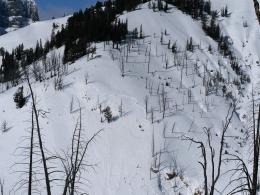
The mountains around Cooke City received an inch of new snow in the last 24 hours and the winds are light. Our primary avalanche concern is avalanches breaking 1-2’ deep on a persistent weak layer of facets and the light accumulation will not notably change this problem. Skiers and riders have regularly reported dangerous avalanches for the last two weeks (avalanche activity log). Without significant loading, the frequency of these slides has declined. Most recently, a rider triggered a 1-2’ deep and 150’ wide avalanche two days ago on Scotch Bonnet Mountain (photo and details). Last week, similar avalanches broke naturally in Republic Creek, Hayden Creek, Sheep Creek and Pebble Creek drainages (photo, details, photo, photo), and on a steep slope downhill of a skier standing on flat terrain south of Cooke City (photo).
While not all slopes are in danger of avalanching, mother nature is providing clear messaging that it remains possible to trigger dangerous slides. If snow intensity increases, avalanches will become more likely. Stick to lower-angle terrain if you see signs of instability or get unstable test results. The danger is MODERATE.
The mountains around Bozeman, Big Sky and West Yellowstone received 3-5” of low-density snow equal to 0.2-0.3” of snow water equivalent (SWE). Avalanche activity will be dependent on the snow surface prior to the storm. In many areas, a thick melt-freeze crust will isolate instabilities to the new and wind-drifted snow. In these areas, anticipate small, loose snow avalanches and shallow slab avalanches. They will start the day relatively small but will increase in size and likelihood with additional snow.
On other slopes, especially at higher elevations, snow is falling on weak layers in the upper 18” of the snowpack. These are most prevalent, but not isolated to the Southern Madison and Southern Gallatin Ranges and the Lionhead area. As Ian mentioned in his video from Lionhead last week, even a small amount of snow falling on these weak layers will result in avalanches. Slides on slopes with underlying weak layers could break deeper and propagate more widely.
Today, signs of instability or unstable results in your assessment of the upper two feet of the snowpack should result in more conservative terrain selection (video). The danger is MODERATE.
If you get out, please send us your observations no matter how brief. You can submit them via our website, email (mtavalanche@gmail.com), phone (406-587-6984), or Instagram (#gnfacobs).
Upcoming Education Opportunities
See our education calendar for an up-to-date list of all local classes. Here are a few select upcoming events.
Every Saturday near Cooke City, 10 a.m.-3 p.m. FREE snowpack update and transceiver/rescue training. Stop by for 20 minutes or more at the Round Lake Warming Hut.
Dave Zinn’s latest article, Understanding what digital slopes angle maps can (and can’t) tell you, is a great read for anyone using apps to identify avalanche terrain.


